Difference between revisions of "2020-05-30 52 9"
From Geohashing
m |
(expedition report for Alfeld) |
||
| Line 1: | Line 1: | ||
| − | |||
| − | |||
| − | |||
| − | |||
| − | |||
| − | |||
| − | |||
| − | |||
| − | |||
{{meetup graticule | {{meetup graticule | ||
| lat=52 | | lat=52 | ||
| Line 16: | Line 7: | ||
== Location == | == Location == | ||
| − | The hash | + | The hash lay at a junction of two fieldways above Alfeld. |
== Participants == | == Participants == | ||
| Line 27: | Line 18: | ||
== Expedition == | == Expedition == | ||
| − | |||
| − | + | I traveled by trains and buses to Alfeld, walked around and found the hash. I waited there until hash o'clock, but no other geohashers arrived. Then I walked to and through the city and traveled home. | |
| − | |||
== Photos == | == Photos == | ||
| − | < | + | |
| − | + | <gallery> | |
| − | -- | + | File:2020-05-30 51 9 GeorgDerReisende 5214.jpg | arrived |
| − | + | File:2020-05-30 51 9 GeorgDerReisende 5282.jpg | the site of geohash | |
| + | File:2020-05-30 51 9 GeorgDerReisende 5283.jpg | looking south | ||
| + | File:2020-05-30 51 9 GeorgDerReisende 5284.jpg | looking east | ||
| + | File:2020-05-30 51 9 GeorgDerReisende 5310.jpg | looking west | ||
| + | File:2020-05-30 51 9 GeorgDerReisende 5313.jpg | looking me | ||
</gallery> | </gallery> | ||
| Line 43: | Line 36: | ||
<!-- Add any achievement ribbons you earned below, or remove this section --> | <!-- Add any achievement ribbons you earned below, or remove this section --> | ||
| − | + | [[Category:Expeditions]] | |
| − | |||
| − | [[Category: | ||
| − | + | [[Category:Expeditions with photos]] | |
| − | + | [[Category:Expedition without GPS]] | |
| − | |||
| − | [[Category:Expedition | ||
| − | |||
| − | |||
| − | |||
| − | |||
| − | |||
| − | |||
| − | |||
| − | |||
| − | |||
| − | |||
| − | |||
| − | |||
[[Category:Coordinates reached]] | [[Category:Coordinates reached]] | ||
| − | |||
| − | |||
| − | |||
| − | |||
| − | |||
| − | |||
| − | |||
| − | |||
| − | |||
| − | |||
| − | |||
| − | |||
| − | |||
| − | |||
| − | |||
| − | |||
| − | |||
| − | |||
Revision as of 12:54, 1 June 2020
| Sat 30 May 2020 in 52,9: 52.0009953, 9.8736736 geohashing.info google osm bing/os kml crox |
Location
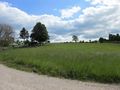
The hash lay at a junction of two fieldways above Alfeld.
Participants
Plans
GeorgDerReisende will be there at hash o'clock.
Expedition
I traveled by trains and buses to Alfeld, walked around and found the hash. I waited there until hash o'clock, but no other geohashers arrived. Then I walked to and through the city and traveled home.
Photos
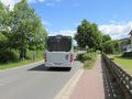
arrived
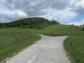
the site of geohash
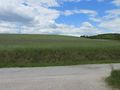
looking south
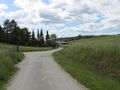
looking east
looking west
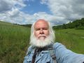
looking me


