Difference between revisions of "2020-09-29 45 4"
(→Photos) |
m (→Achievements: Update ribbon width) |
||
| Line 29: | Line 29: | ||
== Achievements == | == Achievements == | ||
| − | {{#vardefine:ribbonwidth| | + | {{#vardefine:ribbonwidth|100%}} |
{{land geohash | {{land geohash | ||
| latitude = 45 | | latitude = 45 | ||
Latest revision as of 15:39, 4 May 2021
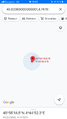
| Tue 29 Sep 2020 in 45,4: 45.9206864, 4.7478470 geohashing.info google osm bing/os kml crox |
Location
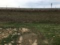
In a harvested field in Billy-le-Vieux (Quincieux).
Participants
Expedition
I took the train from Lyon to Quincieux, then walked 4 kilometers, taking a small detour to avoid being on the main road. I crossed two hamlets named La Chapelle and Billy-le-Vieux and arrived to the coordinates, which were located in a vast harvested field surrounded by a large ditch.
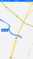
After recording proof, I continued my path westwards, aiming for the next station on the railway line. According to Google, my path was supposed to go under a motorway. What Google had failed to tell me was that I should have brought a tunnel boring machine. So I had to turn back and find another route. Nonetheless I managed to reach Anse in time to take the train back to Lyon.
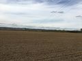
Photos
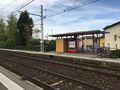
At Quincieux railway station
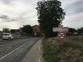
Arriving in Billy-le-Vieux
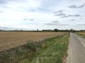
The geohash
The surroundings
Coordinates reached
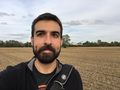
Stupid grin
Let's continue to Anse
You shall not pass


Achievements
Baarde earned the Land geohash achievement
|