Difference between revisions of "2020-10-30 46 7"
([live picture]Reached, details follow when I'm out of here :-) [https://openstreetmap.org/?lat=46.60876820&lon=7.21299280&zoom=16&layers=B000FTF @46.6088,7.2130]) |
|||
| Line 1: | Line 1: | ||
| − | + | {{meetup graticule | |
| − | |||
| − | |||
| − | |||
| − | |||
| − | |||
| − | |||
| − | |||
| − | |||
| lat=46 | | lat=46 | ||
| lon=7 | | lon=7 | ||
| date=2020-10-30 | | date=2020-10-30 | ||
| − | }} | + | }} |
__NOTOC__ | __NOTOC__ | ||
== Location == | == Location == | ||
| − | + | In a forest in the valle Osseyres under the peak Laubspitz. | |
== Participants == | == Participants == | ||
| − | + | * [[User:Tungmar|Tungmar]] ([[User talk:Tungmar|talk]]) | |
| − | |||
== Plans == | == Plans == | ||
| − | + | Take a bus as close as possibel, walk up, go down to the hash. After walk to the end of the valley and see if there is a exit. | |
== Expedition == | == Expedition == | ||
| − | + | I planed to go to a hill in Neuenburg. In the morning I saw this hash which looked relatively easy to access in the hils here. So I changed my plans. | |
| − | + | I took the bus to Charmey, Les Fornys and started walking up the good but steep concrete road. At the junction to the path leading to the hillslope with the hash I thought for some seconds that there is a no trespass sign at the wide open gate. Bringing all my little French knowledge together, I figured that it was just a unfriendly "close the door after you" sign. I left it open as I found it. | |
| − | + | Later on I miserably failed again at an other gate with the same sign: I closed the gate before I went through, walked around it through the non existing fence and opened it again... It was a bit pointless. | |
| + | |||
| + | The path went on, got steeper, muddier and slipperier. Looking at the hill slope in the direction of the hash I just wished I brought a rope with me. Of course I didn't think about that before. | ||
| + | |||
| + | About 100m before the hash I was luky and a easier way to go to the hash than straight down from the nearest point on the path opened bevore me. So I jumped the electric wire which was now there. I had to climb some fallen tree and a small stream. I cam closer and the GPS started to play pong with the coordinates. With each jump I had to follow into more steep, moore muddy and more slippery dird. Finally I catched a reading of under 5m for the second time at one position. I quickly defined it as the hashpoint. It was at the most steep slope in a 50m radius. Well done. | ||
| + | |||
| + | While I tried to stand and not slip all the way down I took some pictures and bearly managed to type and send a "Reached, details follow when I'm out of here :-)" just to say I was here. | ||
| + | |||
| + | Then I climbed up againd. At that point I realized that I still carried my big backpack with clothes and stuff for a week with me and didn't drop it near the path. It must have been exciting! | ||
== Photos == | == Photos == | ||
| Line 35: | Line 34: | ||
<gallery perrow="5"> | <gallery perrow="5"> | ||
| − | Image:2020-10-30_46_7_Tungmar_1604054219203.jpg| | + | Image:2020-10-30_46_7_Tungmar_1604054219203.jpg|I reached the hash with the promised OSM sticker.[https://openstreetmap.org/?lat=46.60876820&lon=7.21299280&zoom=16&layers=B000FTF @46.6088,7.2130] |
</gallery> | </gallery> | ||
| Line 42: | Line 41: | ||
<!-- Add any achievement ribbons you earned below, or remove this section --> | <!-- Add any achievement ribbons you earned below, or remove this section --> | ||
| − | <!-- | + | <!-- Not done yet. Have to reach my computer first. --> |
| − | |||
[[Category:New report]] | [[Category:New report]] | ||
| − | |||
| − | |||
| − | |||
| − | |||
| − | |||
| − | |||
| − | |||
| − | |||
| − | |||
| − | |||
| − | |||
[[Category:Expeditions]] | [[Category:Expeditions]] | ||
| − | + | [[Category:Expeditions with photos]] | |
| − | [[Category:Expeditions with photos]] | ||
| − | |||
| − | |||
| − | |||
| − | |||
| − | |||
[[Category:Coordinates reached]] | [[Category:Coordinates reached]] | ||
| − | |||
| − | |||
| − | |||
| − | |||
| − | |||
| − | |||
| − | |||
| − | |||
| − | |||
| − | |||
| − | |||
| − | |||
| − | |||
| − | |||
| − | |||
| − | |||
| − | |||
| − | |||
Revision as of 21:25, 30 October 2020
| Fri 30 Oct 2020 in 46,7: 46.6087602, 7.2128648 geohashing.info google osm bing/os kml crox |
Location
In a forest in the valle Osseyres under the peak Laubspitz.
Participants
Plans
Take a bus as close as possibel, walk up, go down to the hash. After walk to the end of the valley and see if there is a exit.
Expedition
I planed to go to a hill in Neuenburg. In the morning I saw this hash which looked relatively easy to access in the hils here. So I changed my plans.
I took the bus to Charmey, Les Fornys and started walking up the good but steep concrete road. At the junction to the path leading to the hillslope with the hash I thought for some seconds that there is a no trespass sign at the wide open gate. Bringing all my little French knowledge together, I figured that it was just a unfriendly "close the door after you" sign. I left it open as I found it. Later on I miserably failed again at an other gate with the same sign: I closed the gate before I went through, walked around it through the non existing fence and opened it again... It was a bit pointless.
The path went on, got steeper, muddier and slipperier. Looking at the hill slope in the direction of the hash I just wished I brought a rope with me. Of course I didn't think about that before.
About 100m before the hash I was luky and a easier way to go to the hash than straight down from the nearest point on the path opened bevore me. So I jumped the electric wire which was now there. I had to climb some fallen tree and a small stream. I cam closer and the GPS started to play pong with the coordinates. With each jump I had to follow into more steep, moore muddy and more slippery dird. Finally I catched a reading of under 5m for the second time at one position. I quickly defined it as the hashpoint. It was at the most steep slope in a 50m radius. Well done.
While I tried to stand and not slip all the way down I took some pictures and bearly managed to type and send a "Reached, details follow when I'm out of here :-)" just to say I was here.
Then I climbed up againd. At that point I realized that I still carried my big backpack with clothes and stuff for a week with me and didn't drop it near the path. It must have been exciting!
Photos
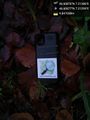
I reached the hash with the promised OSM sticker.@46.6088,7.2130
