|
|
| Line 46: |
Line 46: |
| | {{#vardefine:ribbonwidth|800px}} | | {{#vardefine:ribbonwidth|800px}} |
| | <!-- Add any achievement ribbons you earned below, or remove this section --> | | <!-- Add any achievement ribbons you earned below, or remove this section --> |
| − |
| |
| − | <!-- =============== USEFUL CATEGORIES FOLLOW ================
| |
| − | Delete the next line ONLY if you have chosen the appropriate categories below. If you are unsure, don't worry. People will read your report and help you with the classification. -->
| |
| − |
| |
| − | <!-- ==REQUEST FOR TWITTER BOT== Please leave either the New report or the Expedition planning category in as long as you work on it. This helps the twitter bot a lot with announcing the right outcome at the right moment. -->
| |
| − |
| |
| − | <!-- Potential categories. Please include all the ones appropriate to your expedition -->
| |
| − | <!-- If this is a planning page:
| |
| − | [[Category:Expedition planning]]
| |
| − | -->
| |
| − |
| |
| − | <!-- If all those plans are never acted upon, change [[Category:Expedition planning]] to [[Category:Not reached - Did not attempt]]. -->
| |
| − |
| |
| − | <!-- An actual expedition:
| |
| | [[Category:Expeditions]] | | [[Category:Expeditions]] |
| − | -- and one or more of --
| |
| | [[Category:Expeditions with photos]] | | [[Category:Expeditions with photos]] |
| − | [[Category:Expeditions with videos]]
| |
| | [[Category:Expedition without GPS]] | | [[Category:Expedition without GPS]] |
| − | -->
| |
| − | [[Category:Expeditions]]
| |
| − | [[Category:Expeditions with photos]]
| |
| − | [[Category:Expedition without GPS]]
| |
| − |
| |
| − | <!-- if you reached your coords:
| |
| − | [[Category:Coordinates reached]]
| |
| − |
| |
| − |
| |
| − | -->
| |
| | [[Category:Coordinates reached]] | | [[Category:Coordinates reached]] |
| − | <!-- or if you failed :(
| |
| − | [[Category:Coordinates not reached]]
| |
| − | -- and a reason --
| |
| − | When there is a natural obstacle between you and the target:
| |
| − | [[Category:Not reached - Mother Nature]]
| |
| − |
| |
| − | When there is a man-made obstacle between you and the target:
| |
| − | [[Category:Not reached - No public access]]
| |
| − |
| |
| − | When you failed get your GPS, car, bike or such to work:
| |
| − | [[Category:Not reached - Technology]]
| |
| − |
| |
| − | When you went to an alternate location instead of the actual geohash:
| |
| − | [[Category:Not reached - Attended alternate location]]
| |
| − |
| |
| − | (Don't forget to delete this final close comment marker) -->
| |
Location
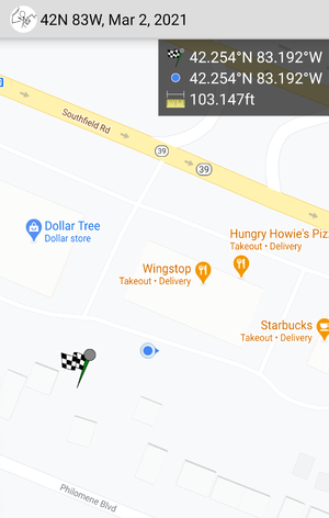
Southfield Road and Dix Highway, just behind Wingstop
Participants
MusicalMitten (talk)
Plans
This was the first geohash I chose to visit! I was familiar with the area and stopped by on my way into downtown Detroit.
Expedition
This was my first, so it was a short adventure. An hour's drive down Telegraph and the Southfield Freeway from the northern suburbs took me within 100 feet of the location.
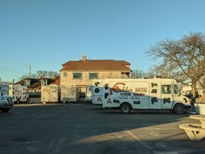
Calder Dairy, a popular locally-owned ice cream shop, is just a mile down the road from the hashpoint.
Tracklog
Photos

Closed for the season, but still a fun evening visit!
Achievements

