Difference between revisions of "2021-03-25 51 9"
From Geohashing
(expedition report for Kassel-Wesertor) |
m (Location) |
||
| Line 36: | Line 36: | ||
[[Category:Not reached - No public access]] | [[Category:Not reached - No public access]] | ||
| + | {{location|DE|HE|KS|city=true}} | ||
Latest revision as of 21:42, 6 April 2021
| Thu 25 Mar 2021 in 51,9: 51.3192778, 9.5175044 geohashing.info google osm bing/os kml crox |
Location
The hash lay in a garden at the Schützenstraße in Kassel
Participants
Plans
This was a must go! I tried a tron walk.
Expedition
I left home on some uncommon ways to reach the hash from the one side. And I found out that the fence of the gardens was at the street and not behind the trees. Behind the trees is a wall, because the street lies on a dam against the floods of the river Fulda. Nine meters away from the hash are some meters too much. Coordinates not reached.
Photos
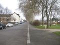
the fence lies between the street and the trees, not between the trees and the gardens

nine meters to hash

proof


