Difference between revisions of "2021-04-15 31 35"
From Geohashing
(→Achievements) |
(→Photos) |
||
| Line 38: | Line 38: | ||
--> | --> | ||
<gallery perrow="5"> | <gallery perrow="5"> | ||
| + | Image:Spring sign.jpg | sign | ||
| + | Image:South hash dolev.jpg | surroundings | ||
| + | Image:Screenshot 20210415-175654.png | proof | ||
| + | Image:North hash dolev.jpg | surroundings | ||
| + | Image:Face dolev.jpg | face | ||
</gallery> | </gallery> | ||
Revision as of 20:00, 17 April 2021
| Thu 15 Apr 2021 in 31,35: 31.9257108, 35.1204693 geohashing.info google osm bing/os kml crox |
Location
It looks like it is close to Dolev.
Participants
Plans
Drive to Dolev and then walk to the hashpoint.
Expedition
I should have hitchhiked to this location but it was kind of late. I drove over to Dolev and on the way I saw a spring with a half full parking lot. I pulled over and "surprise!" I was less than a kilometer from the hashpoint. I walked to the point within an overgrown vineyard, visited the spring, and then walked back to the car. Relatively boring this time.
Tracklog
Photos
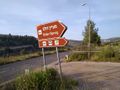
sign
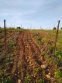
surroundings

proof
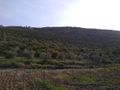
surroundings

face


Achievements