Difference between revisions of "2008-07-02 1 103"
From Geohashing
imported>R0d3n7z m (→Seth, Nathan & r0d3n7z: +map) |
imported>Thomcat (Success/failure category added) |
||
| Line 28: | Line 28: | ||
[[Category:Expeditions with photos]] | [[Category:Expeditions with photos]] | ||
[[Category:Expeditions with videos]] | [[Category:Expeditions with videos]] | ||
| + | [[Category:Coordinates reached]] | ||
| + | <!-- It looks like they were within a few meters of the actual spot - I judge success --> | ||
Revision as of 17:39, 4 August 2008
| Wed 2 Jul 2008 in 1,103: 1.3212162, 103.8560437 geohashing.info google osm bing/os kml crox |
About
1.3212162397543017, 103.85604374530429
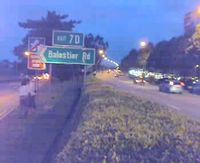
In the outermost lane of the Central Expressway, southbound on the Moulmein flyover just a few meters after Exit 7D (Balestier Road).
Meetup
Seth, Nathan & r0d3n7z
The inaugural meetup in the graticule! We met just after 7pm at Boon Keng MRT station, and walked along Serangoon Road / Balestier Road / Jalan Kebun Limau to get to the location. Video shows the surrounding area, particularly the hedge that stood between us and the exact point (as well as cars zipping past at 80kph). Inconvenient location, so we just took pictures; didn't stay long. Went for dinner at Whampoa market before calling it a day.
- Pictures


