Difference between revisions of "2008-07-16 55 12"
From Geohashing
imported>J0e |
imported>J0e m (→Gallery) |
||
| Line 25: | Line 25: | ||
<gallery caption="The Pictures" widths="200px" heights="200px" perrow="3"> | <gallery caption="The Pictures" widths="200px" heights="200px" perrow="3"> | ||
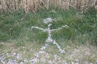
| − | Image:2008-07-16 55 12 marker.JPG| The road was covered with gravel. I used that -- | + | Image:2008-07-16 55 12 marker.JPG| The road was covered with gravel. I used that --[[User:J0e|Joe]] |
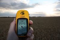
| − | Image:2008-07-16_55_12_gps.JPG| "Old Yeller" behaving nicely. -- | + | Image:2008-07-16_55_12_gps.JPG| "Old Yeller" behaving nicely. --[[User:J0e|Joe]] |
</gallery> | </gallery> | ||
[[Category:Meetup in 55 12]] | [[Category:Meetup in 55 12]] | ||
[[Category:Expeditions]] | [[Category:Expeditions]] | ||
Revision as of 22:10, 16 July 2008
| Tue 8 Jul 2008 in Copenhagen: 55.8055027, 12.5224928 geohashing.info google osm bing/os kml crox |
About
Hash: 55.788475, 12.282822
Closest town: Ganløse
Surroundings: Public road, fields.
Weather forecast: Cloudy, clearing during the day. Showers in the northwestern areas (i.e. Jutland).
Expeditions: J0e
The geohash for 2008-07-16 55 12 is located at the Almagerbakke/Råhøjvej intersection near Ganløse.

