Difference between revisions of "2022-07-18 31 34"
(→Expedition) |
(Categories, link) |
||
| Line 17: | Line 17: | ||
== Participants == | == Participants == | ||
| − | RonK | + | [[User:RonK|RonK]] |
== Plans == | == Plans == | ||
| Line 44: | Line 44: | ||
| name = RonK | | name = RonK | ||
}} | }} | ||
| − | |||
| − | |||
| − | |||
| − | |||
| − | |||
| − | |||
| − | |||
| − | |||
| − | |||
| − | |||
| − | |||
| − | |||
| − | |||
[[Category:Expeditions]] | [[Category:Expeditions]] | ||
[[Category:Expeditions with photos]] | [[Category:Expeditions with photos]] | ||
| − | |||
| − | |||
| − | |||
| − | |||
| − | |||
| − | |||
[[Category:Coordinates reached]] | [[Category:Coordinates reached]] | ||
| − | |||
| − | |||
| − | |||
| − | |||
| − | |||
| − | |||
| − | |||
| − | |||
| − | |||
| − | |||
| − | |||
| − | |||
| − | |||
| − | |||
| − | |||
| − | |||
| − | |||
| − | |||
Revision as of 19:51, 18 July 2022
| Mon 18 Jul 2022 in 31,34: 31.8752307, 34.8593802 geohashing.info google osm bing/os kml crox |
Location
On the border of (a totally tick-free!) agricultural field in Ramot Meir, Israel, just off of an easily accessible road
Participants
Plans
Find geohash location as part of my commute to work. Even though I was much better prepared than for my first, disastrous attempt, I forgot to check Google Street View to see if there was a fence on the side of the road which would prevent me from succeeding --- but I was lucky!
Expedition
Drove to Ramot Meir, stopped at the grocery store parking lot to figure out how to enter the hashpoint's location into my mapping app; From the parking lot drove to a convenient place to park off of the road on the other side from the hashpoint; Arrived by foot after a 30 second walk at the hashpoint at 08:16 and took a few photos; Didn't leave any marker, and anyway I saw from my car before leaving to go on to work that the location was tilled/plowed again a few minutes after I left it.
Gallery
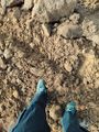
Ramot Meir hashpoint (and my shoes)
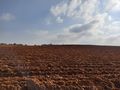
The agricultural field which contained the 2022-07-18 (31, 34) hashpoint (with runner on far side)
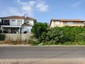
Some houses in Ramot Meir which faced the 2022-07-18 (31, 34) hashpoint (from the opposite side of the road)

Screenshot of OsmAnd+ showing arrival at hashpoint (but too zoomed to show context)
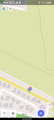
Screenshot of OsmAnd+ showing arrival at hashpoint (with some of the houses on the other side of the road included)


Achievements
RonK earned the Land geohash achievement
|