Difference between revisions of "2022-08-03 43 -121"
([retro picture]Daisy was ready to be done!) |
|||
| Line 1: | Line 1: | ||
| − | + | [[Image:{{{image|2022-08-03 43 -121 frogman 1659974431866.jpg}}}|thumb|left]] | |
| − | + | {{meetup graticule | |
| − | |||
| − | |||
| − | |||
| − | |||
| − | |||
| − | |||
| lat=43 | | lat=43 | ||
| lon=-121 | | lon=-121 | ||
| Line 14: | Line 8: | ||
__NOTOC__ | __NOTOC__ | ||
== Location == | == Location == | ||
| − | + | In Deschutes National Forest between Sunriver and Cascade Lakes Highway. | |
== Participants == | == Participants == | ||
| − | + | *[[User:Frogman|Frogman]] | |
| − | + | *[[User:Higgs|Higgs]] | |
| − | + | *Daisy | |
| − | |||
| − | |||
== Expedition == | == Expedition == | ||
| − | + | After work we borrowed [[User:Benture|Benture's]] truck and headed out to the hashpoint. It was mostly a smooth drive. The first two unpaved forest roads we took were well-maintained, with only the third being a bit sketchy; we had to stop to remove some branches blocking the way. We parked about a kilometer out from the hashpoint, and walked along the road about half of the way, at which point we had to bushwhack through the forest. It was pretty rough going at the start, but cleared up pretty quickly. After around 300 meters of making our own way we came across another road that Google Maps didn't know about. Another 200 meters and we were at the hashpoint. A spider lived there! | |
| − | + | We went back mostly via the secret road, which brought us pretty close to the parked truck. On our drive out, we saw another truck headed up the way we came. A ninja geohasher, perhaps? | |
| − | |||
== Photos == | == Photos == | ||
| − | + | ||
| − | |||
| − | |||
<gallery perrow="5"> | <gallery perrow="5"> | ||
| Line 62: | Line 51: | ||
</gallery> | </gallery> | ||
| − | |||
| − | |||
| − | |||
| − | |||
| − | |||
| − | |||
| − | |||
| − | |||
| − | |||
| − | |||
| − | |||
| − | |||
| − | |||
| − | |||
| − | |||
| − | |||
| − | |||
| − | |||
[[Category:Expeditions]] | [[Category:Expeditions]] | ||
| − | |||
[[Category:Expeditions with photos]] | [[Category:Expeditions with photos]] | ||
| − | |||
| − | |||
| − | |||
| − | |||
| − | |||
[[Category:Coordinates reached]] | [[Category:Coordinates reached]] | ||
| − | |||
| − | |||
| − | |||
| − | |||
| − | |||
| − | |||
| − | |||
| − | |||
| − | |||
| − | |||
| − | |||
| − | |||
| − | |||
| − | |||
| − | |||
| − | |||
| − | |||
| − | |||
Revision as of 16:16, 8 August 2022

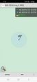
| Wed 3 Aug 2022 in 43,-121: 43.9387439, -121.5117632 geohashing.info google osm bing/os kml crox |
Location
In Deschutes National Forest between Sunriver and Cascade Lakes Highway.
Participants
Expedition
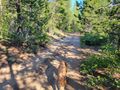
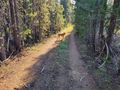
After work we borrowed Benture's truck and headed out to the hashpoint. It was mostly a smooth drive. The first two unpaved forest roads we took were well-maintained, with only the third being a bit sketchy; we had to stop to remove some branches blocking the way. We parked about a kilometer out from the hashpoint, and walked along the road about half of the way, at which point we had to bushwhack through the forest. It was pretty rough going at the start, but cleared up pretty quickly. After around 300 meters of making our own way we came across another road that Google Maps didn't know about. Another 200 meters and we were at the hashpoint. A spider lived there!
We went back mostly via the secret road, which brought us pretty close to the parked truck. On our drive out, we saw another truck headed up the way we came. A ninja geohasher, perhaps?
Photos
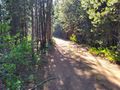
The road we arrived on.
The road ahead.
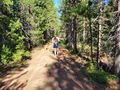
Into the woods!
Some intrepid explorers blazing a trail.
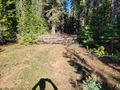
Another road that we could have taken.
Made it!
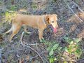
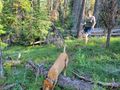
Daisy enjoying the hashpoint.
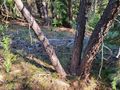
This tree is approximately the location of the hashpoint.
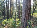
Gorgeous view!
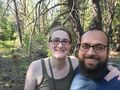
The three geohashers!
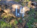
A painted rock on the walk back.
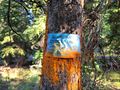
These signs were on a lot of trees that we saw on the walk back.
Daisy was ready to be done!


