Difference between revisions of "2022-12-03 62 29"
m |
|||
| Line 64: | Line 64: | ||
[[Category:Expeditions with photos]] | [[Category:Expeditions with photos]] | ||
[[Category:Coordinates reached]] | [[Category:Coordinates reached]] | ||
| + | {{location|FI|13}} | ||
Revision as of 13:41, 3 December 2022
| Sat 3 Dec 2022 in 62,29: 62.6003317, 29.8920806 geohashing.info google osm bing/os kml crox |
Location
In a forest near highway 74.
The point on a topographic map: [1]
Participants
- Kripakko
- Kripakko's girlfriend
Expedition
This was a nice point that would be well accessible with a little cycling and walking despite the wintry conditions. I stayed at my girlfriend's place, and I did not have the GPS receiver with me, so I downloaded Geohash Droid and gave it a go. We cycled through the city to highway 74 and stopped near the hashpoint. I walked the last 90 metres to visit the point while my girlfriend waited at the roadside. Nothing really interesting happened at any point.
I did not have GPS tracking on, but using the map I estimated that I had cycled about 19.9 kilometres and walked about 190 metres. I also did not have a thermometer, but the weather forecasts I looked at showed a temperature of −5 °C which felt more like −10 °C with wind. That it pretty much how I felt too. I will have a look at this day's weather statistics tomorrow when they are published.
Photos
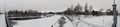
The Pielisjoki river.
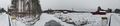
The Iiksenjoki river.
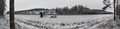
Highway 74 where I parked the bicycle, about 90 metres to go.
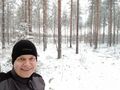
Selfie at the hashpoint.

Proof of location #1
Proof of location #2


Achievements
Kripakko earned the Land geohash achievement
|
Kripakko earned the Bicycle geohash achievement
|
Kripakko earned the Frozen Geohash Achievement
|