Difference between revisions of "Tidal River, Australia"
From Geohashing
m (Marking as inactive due to no recent expeditions) |
(→Expedition) |
||
| Line 19: | Line 19: | ||
== Expedition == | == Expedition == | ||
| − | [[Image:Arrow2.png|12px]] Jul [[2022-07-11 -39 146]] - [[User:Mdixon4|Mdixon4]], Rhonda, [[User:Stevage|Stevage]] - | + | [[Image:Arrow2.png|12px]] Jul [[2022-07-11 -39 146]] - [[User:Mdixon4|Mdixon4]], Rhonda, [[User:Stevage|Stevage]] - Graticule unlocked, hash near Tidal River.<br/> |
[[File:2022-07-11 -39 146 stevage 1657522943442.jpg|thumb|300px|First ever geohash, in [[2022-07-11 -39 146|July 2022]].]] | [[File:2022-07-11 -39 146 stevage 1657522943442.jpg|thumb|300px|First ever geohash, in [[2022-07-11 -39 146|July 2022]].]] | ||
Latest revision as of 22:38, 24 March 2024
| Pakenham | Traralgon | Sale |
| Bass Strait, Australia | Tidal River | Lughrata |
| Smithton | Tenth Island | Waterhouse |
|
Today's location: geohashing.info google osm bing/os kml crox | ||
This graticule is located at -39,146. Today's location
98.3% of this graticule is water, and the rest is national park, with only one public road giving access to a very small part of it.
It is named after the camping ground at Tidal River, where thousands of people camp each summer.
Expedition
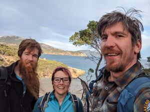
![]() Jul 2022-07-11 -39 146 - Mdixon4, Rhonda, Stevage - Graticule unlocked, hash near Tidal River.
Jul 2022-07-11 -39 146 - Mdixon4, Rhonda, Stevage - Graticule unlocked, hash near Tidal River.

First ever geohash, in July 2022.