Difference between revisions of "Pudasjärvi West, Finland"
From Geohashing
m |
|||
| Line 13: | Line 13: | ||
| s = [[Vaala, Finland|Vaala]] | | s = [[Vaala, Finland|Vaala]] | ||
| se = [[Kajaani, Finland|Kajaani]] | | se = [[Kajaani, Finland|Kajaani]] | ||
| − | }} | + | }} __NOTOC__ |
| − | + | This graticule is located at [[65,26]]. {{Today's location|lat=65|lon=26}} | |
| − | [{{Today's location|lat=65|lon=26 | ||
| − | + | The graticule is named after Pudasjärvi, the centrum of which is split in half by the E27° meridian. | |
| + | The centrum, named Kurenalus, is the largest urban area and has a population of about 4000. | ||
| + | Other urban areas are Ranua, Vesala and Ylikiiminki. | ||
| + | A large fraction of the graticule is bog, and there are several [https://en.wikipedia.org/wiki/Peat peat] production areas all over. | ||
| + | == Regions in the graticule == | ||
| + | [[Image:regions_65_26_6.svg|x400px|frameless|Regions in the graticule]] | ||
| + | {| class="wikitable" | ||
| + | !Name!!Geohash<br />probability | ||
| + | |- | ||
| + | |<span style="color:rgb(255, 0, 255)">■</span> North Ostrobothnia||72.8% | ||
| + | |- | ||
| + | |<span style="color:rgb(0, 255, 0)">■</span> Lapland||27.2% | ||
| + | |} | ||
| + | |||
| + | == Municipalities in the graticule == | ||
| + | [[Image:regions_65_26_8.svg|x400px|frameless|Municipalities in the graticule]] | ||
| + | {| class="wikitable" | ||
| + | !Name!!Geohash<br />probability | ||
| + | |- | ||
| + | |<span style="color:rgb(255, 191, 64)">■</span> Pudasjärvi||45.4% | ||
| + | |- | ||
| + | |<span style="color:rgb(255, 64, 191)">■</span> Ranua||27.2% | ||
| + | |- | ||
| + | |<span style="color:rgb(0, 0, 255)">■</span> Oulu||19.1% | ||
| + | |- | ||
| + | |<span style="color:rgb(0, 255, 0)">■</span> Ii||4.8% | ||
| + | |- | ||
| + | |<span style="color:rgb(0, 128, 128)">■</span> Utajärvi||3.4% | ||
| + | |} | ||
== Meetups == | == Meetups == | ||
Revision as of 21:24, 4 June 2023
|
Latest Coordinates and Map Quick-Links | |
|---|---|
| Thursday 2024-12-19 | 65.5999586, 26.2089575 |
| Rovaniemi | Vanttauskoski | Kemijärvi |
| Oulu | Pudasjärvi West | Pudasjärvi East |
| Kempele | Vaala | Kajaani |
|
Today's location: geohashing.info google osm bing/os kml crox | ||
This graticule is located at 65,26. Today's location
The graticule is named after Pudasjärvi, the centrum of which is split in half by the E27° meridian. The centrum, named Kurenalus, is the largest urban area and has a population of about 4000. Other urban areas are Ranua, Vesala and Ylikiiminki. A large fraction of the graticule is bog, and there are several peat production areas all over.
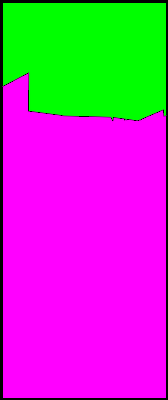
Regions in the graticule
| Name | Geohash probability |
|---|---|
| ■ North Ostrobothnia | 72.8% |
| ■ Lapland | 27.2% |
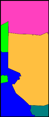
Municipalities in the graticule
| Name | Geohash probability |
|---|---|
| ■ Pudasjärvi | 45.4% |
| ■ Ranua | 27.2% |
| ■ Oulu | 19.1% |
| ■ Ii | 4.8% |
| ■ Utajärvi | 3.4% |
Meetups
- 2023-02-08 65 26 In Niemiharju, Ylikiiminki. Reached successfully by Kripakko

