Difference between revisions of "2023-06-09 52 0"
PeterRoder (talk | contribs) |
PeterRoder (talk | contribs) |
||
| Line 17: | Line 17: | ||
I left home early, about 8:45, hoping the area around the hash wouldn't be too busy when I arrived. The journey to the hash was completely unremarkable, being a route I walk weekly. | I left home early, about 8:45, hoping the area around the hash wouldn't be too busy when I arrived. The journey to the hash was completely unremarkable, being a route I walk weekly. | ||
| − | The rest of the story | + | The rest of the story is best told as images with captions rather than paragraphs. |
| − | + | {|class="wikitable" style="margin-right:10px;" | |
| + | |[[Image:2023-06-09 52 0 nearly there.jpg|frameless|upright]] <br> Oh no. Do I have to walk through that? | ||
| + | |[[Image:2023-06-09 52 0 path.jpg|frameless|upright]] <br> Aha, there is a way round! | ||
| + | |[[Image:2023-06-09 52 0 at the hash.jpg|frameless|upright]] <br> 1m away is good enough. | ||
| + | |} | ||
| − | + | [[Image:2023-06-09 52 0 me.jpg|upright|thumb|left|The face of a geohasher who is thinking he probably should be doing something a bit more important]] | |
| − | |||
| − | + | In the background of the photo of me, you can see Jesus lock. This lock divides the river into two distinct sections in Cambridge: Upstream, through the backs of the colleges is where you'll see punts. Downstream of the lock there are rowing boats instead. The lock is the furthest upstream narrowboats can get along the river during the summer; during winter they are allowed to journey up as far as the weir near Darwin college. | |
| − | |||
| − | |||
| − | |||
| − | |||
| − | |||
| − | + | [[Image:2023-06-09 52 0 stats.jpg|upright|thumb|right|Some stats from the expedition]] | |
| − | |||
| − | |||
| − | + | The return journey wasn't particularly interesting. I tried to use a slightly different route for variety, but I didn't want to waste too much time, so it was mostly the same route. | |
| − | |||
| − | |||
| − | |||
| − | + | == Tracklog == | |
| + | To be added when I find the cable for my GPS (hopefully when I get home from uni). | ||
| − | |||
| − | |||
| − | |||
| − | |||
| − | + | __NOTOC__ | |
| − | |||
[[Category:Expeditions]] | [[Category:Expeditions]] | ||
| − | |||
[[Category:Expeditions with photos]] | [[Category:Expeditions with photos]] | ||
| − | + | ||
| − | |||
| − | |||
| − | |||
| − | |||
[[Category:Coordinates reached]] | [[Category:Coordinates reached]] | ||
| − | |||
| − | |||
| − | |||
| − | |||
| − | |||
| − | |||
| − | |||
| − | |||
| − | |||
| − | |||
| − | |||
| − | |||
| − | |||
| − | |||
| − | |||
| − | |||
| − | |||
| − | |||
Revision as of 19:06, 9 June 2023
| Fri 9 Jun 2023 in 52,0: 52.2129778, 0.1220305 geohashing.info google osm bing/os kml crox |
Location
Right next to the river on the edge of Jesus Green, in Cambridge
Participants
Plans
This was a near-perfect oppertunity: a publicly accessible location in my city, only about a half hour walk away. The main drawback was that I had a 3 hour exam in the afternoon, couldn't guarantee availability in the evening, and probably should have been revising in the morning. Oh well, when the hash calls, you have to listen.
Expedition
I left home early, about 8:45, hoping the area around the hash wouldn't be too busy when I arrived. The journey to the hash was completely unremarkable, being a route I walk weekly.
The rest of the story is best told as images with captions rather than paragraphs.
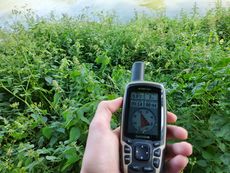
 Oh no. Do I have to walk through that? |
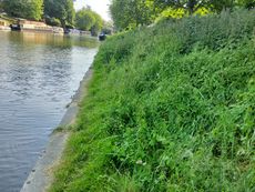
 Aha, there is a way round! |
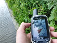
 1m away is good enough. |
In the background of the photo of me, you can see Jesus lock. This lock divides the river into two distinct sections in Cambridge: Upstream, through the backs of the colleges is where you'll see punts. Downstream of the lock there are rowing boats instead. The lock is the furthest upstream narrowboats can get along the river during the summer; during winter they are allowed to journey up as far as the weir near Darwin college.
The return journey wasn't particularly interesting. I tried to use a slightly different route for variety, but I didn't want to waste too much time, so it was mostly the same route.
Tracklog
To be added when I find the cable for my GPS (hopefully when I get home from uni).

