Difference between revisions of "2023-10-04 47 8"
From Geohashing
Globescorer (talk | contribs) (→Expedition) |
(Categories) |
||
| Line 35: | Line 35: | ||
{{consecutive geohash 2 | count = 2 | latitude = 47 | longitude = 8 | date = 2023-10-03 | name = globescorer }} | {{consecutive geohash 2 | count = 2 | latitude = 47 | longitude = 8 | date = 2023-10-03 | name = globescorer }} | ||
{{land geohash|date=2023-09-05|latitude=47|longitude=8|name=[[User:globescorer|globescorer]]|image=2023-10-04 47 8 The Geohash.jpg}} | {{land geohash|date=2023-09-05|latitude=47|longitude=8|name=[[User:globescorer|globescorer]]|image=2023-10-04 47 8 The Geohash.jpg}} | ||
| + | |||
| + | __NOTOC__ | ||
| + | [[Category:Expeditions]] | ||
| + | [[Category:Coordinates reached]] | ||
| + | [[Category:Expeditions with photos]] | ||
{{location|CH|SH}} | {{location|CH|SH}} | ||
Latest revision as of 17:13, 4 October 2023
| Wed 4 Oct 2023 in 47,8: 47.6613824, 8.4857448 geohashing.info google osm bing/os kml crox |
Location
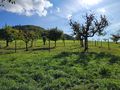
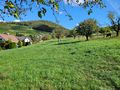
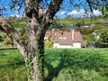
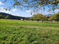
This Geohash is located under a tree in a meadow in Osterfingen (SH), Switzerland.
Participants
Plans
In my lunchtime I want to ride my motorcycle to this geohash.
Expedition
Success!
I drove to the north over german territory to reach the todays geohash in Osterfingen, Switzerland. I parked as near as possible and had to walk only a few steps under a tree in a meadow. So, then I took the pictures and proofs and rode back to the office I work.
Photos
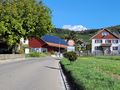
Osterfingen
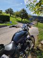
motorcycleparking
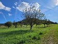
Geohashtree

The Geohash

The Proof 1

The Proof 2
south
east
north
west


Achievements
globescorer earned the Consecutive geohash achievement
|
globescorer earned the Land geohash achievement
|