Difference between revisions of "2023-11-11 41 12"
m (→Participants: ~~~) |
m (→Achievements: Add bicycle ~~~) |
||
| Line 49: | Line 49: | ||
__NOTOC__ | __NOTOC__ | ||
| + | {{bicycle geohash | ||
| + | | latitude={{#explode:{{SUBPAGENAME}}| |1}} | ||
| + | | longitude={{#explode:{{SUBPAGENAME}}| |2}} | ||
| + | | date={{#explode:{{SUBPAGENAME}}| |0}} | ||
| + | | distance=5km | ||
| + | | bothways=true | ||
| + | }} | ||
[[Category:Expeditions]] | [[Category:Expeditions]] | ||
[[Category:Expeditions with photos]] | [[Category:Expeditions with photos]] | ||
Revision as of 10:09, 14 November 2023
| Sat 11 Nov 2023 in 41,12: 41.8965614, 12.4653802 geohashing.info google osm bing/os kml crox |
Location
In the middle of the Tiber, just upstream of the Ponte Giuseppe Mazzini
Participants
Right now only me, Jezza (talk), but for the first time ever I plan to be on the bridge or on the cycle path even nearer the geohash, at 4pm.
Plans
I will take the opportunity to go for a bicycle ride along the river and will be at the geohash or on the bridge at 16:00
Expedition
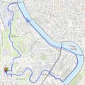
I got on my bike, rode for about 5 minutes to the lighthouse on the Janiculum hill, where I took a photo. Then down the hill and along the river for a few minutes to the Ponte Mazzini. I checked my location and decided I could get even closer by going down the perilous staircase to the cycle path along the edge of the Tiber. Got as close as I could to the geohash in the middle of the river and snapped a picture of the bicycle. Then treated myself to a longer ride along the cycle path to a spot where I could fold up the bike and let a bus take me home.
Tracklog
Photos
Achievements
This user earned the Bicycle geohash achievement
|


