Difference between revisions of "2024-07-13 50 8"
Green guy! (talk | contribs) (Expedition was successful, more info tomorrow; sort the information related to myself and Monotow) |
Green guy! (talk | contribs) (Put Monotof before myself everywhere (except for Plans) as his expedition was earlier; Update notice because I want to work on this on Monday, not Sunday) |
||
| Line 36: | Line 36: | ||
== Expedition == | == Expedition == | ||
| + | === Monotof === | ||
| + | Even though it was pretty cloudy and some of those clouds were rather dark, i got on my bike and rode through the hilly Vordertaunus towards Oberursel. Riding through the Residential zones of Bad Homburg and Oberursel especially on the hillsides there were some quite nice homes. | ||
| + | |||
| + | I arrived at the hashpoint at ~11:50 and took the prerequisite pictures. Afterwards i sat on a nearby bench and ate the lunch i brought: Bread, Cheese, Snack-Salami and Blueberries. After keeping a lookout for [[User:Green guy!|Green guy!]] without luck for ~30 min i got back on my bike to ride home. | ||
| + | |||
=== Green guy! === | === Green guy! === | ||
<strong>{{note|[Quick info for [[User:Monotof|Monotof]]] I reached the coordinates at roughly 15:05 because (1) my parents weren’t ready before 12:00, (2) there was an unexpected delay, and (3) we had lunch before going to the hashpoint.}}</strong> | <strong>{{note|[Quick info for [[User:Monotof|Monotof]]] I reached the coordinates at roughly 15:05 because (1) my parents weren’t ready before 12:00, (2) there was an unexpected delay, and (3) we had lunch before going to the hashpoint.}}</strong> | ||
| − | {{note|A beautiful trip and coordinates were reached, but I’m so tired from it … I’ll probably write the report tomorrow.}} | + | {{note|A beautiful trip and coordinates were reached, but I’m so tired from it … <s>I’ll probably write the report tomorrow.</s> I don’t want to do this kind of <em>work</em> on a Sunday, so I prefer to postpone it by one more day.}} |
<!-- | <!-- | ||
[Note to self] Don’t forget to write about: | [Note to self] Don’t forget to write about: | ||
| Line 53: | Line 58: | ||
==== Final verdict ==== | ==== Final verdict ==== | ||
| + | == Tracklog: Walking to the hashpoint / Visiting _____ == | ||
=== Monotof === | === Monotof === | ||
| − | + | {{tracklog | 2024-07-13 1705255129 Hashpoint 240713.gpx}} | |
| − | |||
| − | |||
| − | |||
=== Green guy! === | === Green guy! === | ||
<!-- not required if you have a “coordinates reached” screenshot --> | <!-- not required if you have a “coordinates reached” screenshot --> | ||
| Line 69: | Line 72: | ||
<!-- {{Tracklog|_____.gpx}} --> | <!-- {{Tracklog|_____.gpx}} --> | ||
| + | == Pictures == | ||
=== Monotof === | === Monotof === | ||
| − | + | <gallery mode="packed" heights="200px"> | |
| + | Image:2024-07-13_50_8_Monotof_1720864728196.jpg|Panorama [https://openstreetmap.org/?mlat=50.21666200&mlon=8.55115600&zoom=16 @50.2167,8.5512] | ||
| + | Image:20240713 115245.jpg| Stupid Grin™ | ||
| + | Image:Screenshot 20240713 115200 Geohash Droid.jpg|Proof | ||
| + | </gallery> | ||
| − | |||
=== Green guy! === | === Green guy! === | ||
<!-- 5–10 pictures are already sufficient! Only upload the most interesting ones! --> | <!-- 5–10 pictures are already sufficient! Only upload the most interesting ones! --> | ||
<!-- File:2024-##-## ## ## _____.jpg | alt=Alt text | Witty Captions (not required!) --> | <!-- File:2024-##-## ## ## _____.jpg | alt=Alt text | Witty Captions (not required!) --> | ||
<gallery mode=packed> | <gallery mode=packed> | ||
| − | |||
| − | |||
</gallery> | </gallery> | ||
<!-- IDEA: Think about taking a panorama picture of the hashpoint site! --> | <!-- IDEA: Think about taking a panorama picture of the hashpoint site! --> | ||
<!-- IDEA: Maybe add pictures to the main expedition report text instead of having a gallery! | <!-- IDEA: Maybe add pictures to the main expedition report text instead of having a gallery! | ||
SUB-IDEA: Maybe even do this in a list format so pictures and corresponding text are always next to each other! --> | SUB-IDEA: Maybe even do this in a list format so pictures and corresponding text are always next to each other! --> | ||
| − | |||
| − | |||
| − | |||
| − | |||
| − | |||
| − | |||
| − | |||
== Achievements == | == Achievements == | ||
Revision as of 15:42, 14 July 2024
| Sat 13 Jul 2024 in 50,8: 50.2166294, 8.5512527 geohashing.info google osm bing/os kml crox |
Location
On a footway in the northwest residential area of Oberursel (Taunus), Hochtaunus county, Hesse, Germany. The Camp-King-Park lies to the east.
This day’s weather: sunny with a few clouds, 20–23 °C
Participants
Forenoon:
Noon to afternoon:
- Green guy! (talk)
- Green guy!’s mother (no consent to publish photos of her)
- Green guy!’s father (no consent to publish photos of him)
Plans
Green guy!
- Drive to Oberursel in the forenoon
- Park our car near the hashpoint
- Walk to the coordinates
- Have an enjoyable walk in the Camp-King-Park
- Have lunch at a nearby restaurant
- Drive back home
Monotof
- Cycle to the hashpoint
- Have lunch in the nearby park
- Cycle home
Expedition
Monotof
Even though it was pretty cloudy and some of those clouds were rather dark, i got on my bike and rode through the hilly Vordertaunus towards Oberursel. Riding through the Residential zones of Bad Homburg and Oberursel especially on the hillsides there were some quite nice homes.
I arrived at the hashpoint at ~11:50 and took the prerequisite pictures. Afterwards i sat on a nearby bench and ate the lunch i brought: Bread, Cheese, Snack-Salami and Blueberries. After keeping a lookout for Green guy! without luck for ~30 min i got back on my bike to ride home.
Green guy!
![]() Note: [Quick info for Monotof] I reached the coordinates at roughly 15:05 because (1) my parents weren’t ready before 12:00, (2) there was an unexpected delay, and (3) we had lunch before going to the hashpoint.
Note: [Quick info for Monotof] I reached the coordinates at roughly 15:05 because (1) my parents weren’t ready before 12:00, (2) there was an unexpected delay, and (3) we had lunch before going to the hashpoint.
![]() Note: A beautiful trip and coordinates were reached, but I’m so tired from it …
Note: A beautiful trip and coordinates were reached, but I’m so tired from it … I’ll probably write the report tomorrow. I don’t want to do this kind of work on a Sunday, so I prefer to postpone it by one more day.
The way there / ___ visit
As planned, my parents and I drove to __RESTAURANT__ in __STADT__ via B123. We had a delightful time there; I ate a delicious __MEAL__.
Reaching the coordinates
After lunch, we visited the hashpoint: We parked our car ____ and ____
The way back home
Final verdict
Tracklog: Walking to the hashpoint / Visiting _____
Monotof
Green guy!
Pictures
Monotof
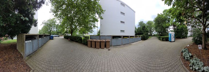
Panorama @50.2167,8.5512
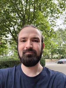
Stupid Grin™
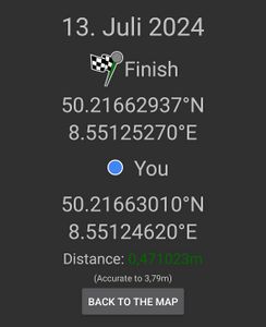
Proof


Green guy!
Achievements
Monotof
Monotof earned the OpenStreetMap achievement
|
Green guy!: Recurring
I already earned these from an earlier geohash, but fulfilled the conditions again on this one.