Difference between revisions of "2024-07-05 48 7"
From Geohashing
(→Achievements) |
(→Achievements) |
||
| Line 65: | Line 65: | ||
| name = [[User:LeslieHapablap|LeslieHapablap]] | | name = [[User:LeslieHapablap|LeslieHapablap]] | ||
| − | }} | + | }} |
| + | Proof of the speedrun in the linked gpx: First track point at <nowiki><time>2024-07-05T05:15:08.149Z</time></nowiki>, last track point at <nowiki><time>2024-07-05T06:03:03.417Z</time></nowiki>. | ||
__NOTOC__ | __NOTOC__ | ||
<!-- =============== USEFUL CATEGORIES FOLLOW ================ | <!-- =============== USEFUL CATEGORIES FOLLOW ================ | ||
Revision as of 20:56, 14 July 2024
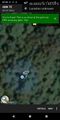
| Fri 5 Jul 2024 in 48,7: 48.0805176, 7.8572925 geohashing.info google osm bing/os kml crox |
Location
In a forest near Denzlingen.
Participants
Plans
I got an app alert about a nearby hash point. Indeed, it was almost directly on my route to work.
Expedition
Not much to tell :) Biked to work, made a very short detour to reach the hash point. It was located in a forest area, and the mosquitos enjoyed my visit.
Tracklog
Photos
Obligatory proof.
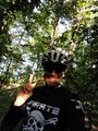
Obligatory stupid grin.
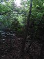
A forest.


Achievements
LeslieHapablap earned the Land geohash achievement
|
LeslieHapablap earned the Bicycle geohash achievement
|
LeslieHapablap earned the Speedrun achievement
|
Proof of the speedrun in the linked gpx: First track point at <time>2024-07-05T05:15:08.149Z</time>, last track point at <time>2024-07-05T06:03:03.417Z</time>.