Difference between revisions of "2024-09-15 62 27"
m |
|||
| Line 31: | Line 31: | ||
__NOTOC__ | __NOTOC__ | ||
| − | |||
| − | |||
| − | |||
| − | |||
| − | |||
| − | |||
| − | |||
| − | |||
| − | |||
| − | |||
[[Category:Expeditions]] | [[Category:Expeditions]] | ||
| − | |||
[[Category:Expeditions with photos]] | [[Category:Expeditions with photos]] | ||
| − | |||
| − | |||
| − | |||
| − | |||
[[Category:Coordinates reached]] | [[Category:Coordinates reached]] | ||
| − | |||
| − | |||
| − | |||
| − | |||
| − | |||
| − | |||
| − | |||
| − | |||
| − | |||
| − | |||
| − | |||
| − | |||
| − | |||
| − | |||
Revision as of 20:38, 23 September 2024
| Sun 15 Sep 2024 in Kuopio: 62.9435660, 27.9466165 geohashing.info google osm bing/os kml crox |
Location
In a forest near Kaarinlahti, Kuopio.
The point on a topographic map: [1]
Participants
Expedition
I was going to drive from Joensuu to Oulu today, and this hashpoint would be an easy visit if I would take the route via Siilinjärvi and Iisalmi. Wishing to avoid driving back and forth, I chose to exit the highway early and follow some small gravel roads that would bring me to the intersection next to the hashpoint. It ended up being a mistake: the long stretch of road (Kirkkokalliontie) had a very reasonable speed limit of 30 km/h, and it was riddled with potholes and tall rocks. I was too busy avoiding the obstacles to take a single photo. The bottom of the car ended up hitting a couple of rocks despite my best efforts, but as far as I could tell they caused no damage. It was a cool adventure, but I should have just chosen the easier, safer and much faster route.
I finally reached the intersection and looked for a widening where I could park the car for a while. The roads were narrow enough that I would not be able to park anywhere without blocking them, so I just stopped the car somewhere convenient and quickly ran to visit the hashpoint. It was possible, though unlikely, that I would piss someone by blocking the road, but then I would be able to come back almost immediately to move the car. Thankfully, nobody came around while I was away. I continued driving soon and returned to the highway. The last stretch of gravel road was nice and smooth, almost like a proper rally road. About 250 kilometres of paved road home afterwards were quite dull.
Tracklog
I recorded only this short stretch around and including the diversion from the highway.
Photos
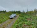
Where I parked the car. I very likely blocked the road completely, but nobody else was using the road during the few minutes I was away.
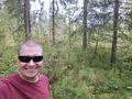
Selfie at the hashpoint.
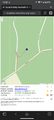
Proof of location and time, screenshot of QDGN.


Achievements
Kripakko earned the Land geohash achievement
|