Difference between revisions of "2024-04-20 41 -78"
Pedalpusher (talk | contribs) (New report) |
Pedalpusher (talk | contribs) (Added pictures) |
||
| Line 18: | Line 18: | ||
== Photos == | == Photos == | ||
| − | <gallery perrow=" | + | <gallery perrow="8"> |
| − | Image: | + | Image:2024-04-20 41 -78 unknownStorageTank.jpg| About halfway out on the trail, we saw this through the woods near a pipeline but not sure what it's for. |
| − | Image: | + | Image:2024-04-20 41 -78 blankSign.jpg| Getting closer, we saw a sign on the trail thinking it would have some info on it. |
| − | Image: | + | Image:2024-04-20 41 -78 snake1.jpg| Once off the trail, we came across this guy. |
| − | Image: | + | Image:2024-04-20 41 -78 snake2.jpg| About halfway through the woods from the trail, we saw another snake. |
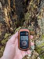
| − | Image: | + | Image:2024-04-20 41 -78 gps.jpg| Made it to the hash! |
| − | Image: | + | Image:2024-04-20 41 -78 gps2.jpg| Accuracy. |
| − | Image: | + | Image:2024-04-20 41 -78 viewNorth.jpg| View North from where we walked in (I think). |
| + | Image:2024-04-20 41 -78 viewWest.jpg| I normally turn counter-clockwise when taking pics so this should be to the West. | ||
| + | Image:2024-04-20 41 -78 viewSouth.jpg| View South. | ||
| + | Image:2024-04-20 41 -78 viewEast.jpg| View East. | ||
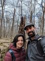
| + | Image:2024-04-20 41 -78 stupidGrins.jpg| Standard Stupid Grins. | ||
| + | Image:2024-04-20 41 -78 toad.jpg| On the way back to the trail, we found this toad in the Snow Drops. | ||
| + | Image:2024-04-20 41 -78 cacheView.jpg| The cache at our turnaround point. | ||
| + | Image:2024-04-20 41 -78 distToHash.jpg| Distance from the Cache back to the Hash for a Hash Collision Event (HM) | ||
| + | Image:2024-04-20 41 -78 atCache.jpg| Here we are at the Cache. | ||
</gallery> | </gallery> | ||
| Line 45: | Line 53: | ||
}} | }} | ||
| − | |||
[[Category:Expeditions]] | [[Category:Expeditions]] | ||
[[Category:Coordinates reached]] | [[Category:Coordinates reached]] | ||
| − | + | [[Category:Expeditions with photos]] | |
Revision as of 19:53, 11 October 2024
| Sat 20 Apr 2024 in 41,-78: 41.9822948, -78.9163268 geohashing.info google osm bing/os kml crox |
Location
Alleghany National Recreation Area, off the North Country Trail
Participants
Expedition
I'm writing this report up very late, so I don't remember why we didn't aim for an Official Sat Meetup here, but it's always a good time when you can get into the woods for a hike and a Geohash.
A little fuzzy on the details, but I recall a long drive down after lunch (or maybe we had lunch on the way), but getting to the parking area, we saw lots of fisherman around as there are trout streams in the area as well. Once in the woods, we did see a couple walking out, but otherwise had the woods to ourselves. Once we got as close as we could on the trail, we headed toward the hash. Going up the first hill, we came across a decent sized garter snake that probably recently came out of hibernation. There wasn't any leaves on the trees/shrubs yet so getting through the woods to the hash wasn't too difficult.
I had a short GPS dance to get a good reading and got some pics of the area before we headed back to the trail. We still had some time so we walked a little further into the woods on the trail for maybe 15 minutes. When my alarm went off to turn around, we weren't really at any good spots so we walked a tiny bit longer until we came across a large rotted out stump and we thought this was a good marker to turn around at. We might have just been relaxing for a moment, or maybe having a snack, but looking into the stump, we saw a container. I pulled it out and found we stumbled upon a GeoCache. I fired up the GPS again and found we were within the Honorable Mention radius for a Hash Collision event!
After signing the log and putting it back, we headed out and for home to do whatever we had planned for the evening.
Photos
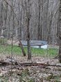
About halfway out on the trail, we saw this through the woods near a pipeline but not sure what it's for.
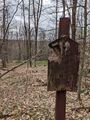
Getting closer, we saw a sign on the trail thinking it would have some info on it.
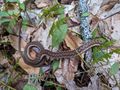
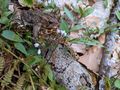
Once off the trail, we came across this guy.
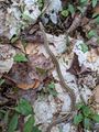
About halfway through the woods from the trail, we saw another snake.
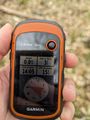
Made it to the hash!

Accuracy.
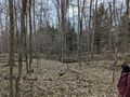
View North from where we walked in (I think).
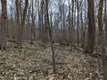
I normally turn counter-clockwise when taking pics so this should be to the West.
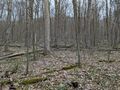
View South.
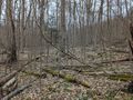
View East.
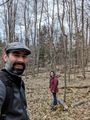
Standard Stupid Grins.
On the way back to the trail, we found this toad in the Snow Drops.
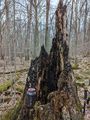
The cache at our turnaround point.
Distance from the Cache back to the Hash for a Hash Collision Event (HM)
Here we are at the Cache.


Ribbons
This user earned the Land geohash achievement
|
Pedalpusher and J earned the Hash collision honorable mention
|