Difference between revisions of "2024-10-19 48 7"
(→Plans) |
(→To the hashpoint) |
||
| Line 16: | Line 16: | ||
== Expedition == | == Expedition == | ||
==== To the hashpoint ==== | ==== To the hashpoint ==== | ||
| − | We drove into the village of Wagshurst and out the southern end over the small river Rench. We checked and were pleasantly surprised to find that the road through the fields was a properly paved road (or at least an easily driveable path later on) instead of a rough dirt path only meant for tractors we expected. With this we were able to drive most of the way towards the hashpoint (560m away) and had high hopes of reaching it. | + | We drove into the village of Wagshurst and out the southern end over the small river Rench. We checked and were pleasantly surprised to find that the road through the fields was a properly paved road (or at least an easily driveable path later on) instead of a rough dirt path only meant for tractors we expected. With this we were able to drive most of the way towards the hashpoint (560m away) before parking the car and had high hopes of reaching it. |
Unfortunately we quickly realized that the forest the hashpoint was in is pretty much all wetlands and with the previous rainfalls it really lived up to the name. All of it was moist, some parts were really muddy but the most problematic for our venture were the ditches with water in them running all throughout the forest and alongside many of the pathes. Even though they were not very wide or deep, especially with their muddy banks we did not want to risk attempting to jump those as we planned on visiting a restaurant for lunch afterwards. | Unfortunately we quickly realized that the forest the hashpoint was in is pretty much all wetlands and with the previous rainfalls it really lived up to the name. All of it was moist, some parts were really muddy but the most problematic for our venture were the ditches with water in them running all throughout the forest and alongside many of the pathes. Even though they were not very wide or deep, especially with their muddy banks we did not want to risk attempting to jump those as we planned on visiting a restaurant for lunch afterwards. | ||
Revision as of 18:36, 19 October 2024
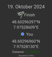
| Sat 19 Oct 2024 in 48,7: 48.6029640, 7.9752861 geohashing.info google osm bing/os kml crox |
Location
In a wetland forest near Wagshurst
Participants
- Monotof
- Lacreo
Plans
The hashpoint was just off the Autobahn on our route and the weather was nice (or at least not raining) so we decided to try to reach the hashpoint just before lunch.
Expedition
To the hashpoint
We drove into the village of Wagshurst and out the southern end over the small river Rench. We checked and were pleasantly surprised to find that the road through the fields was a properly paved road (or at least an easily driveable path later on) instead of a rough dirt path only meant for tractors we expected. With this we were able to drive most of the way towards the hashpoint (560m away) before parking the car and had high hopes of reaching it.
Unfortunately we quickly realized that the forest the hashpoint was in is pretty much all wetlands and with the previous rainfalls it really lived up to the name. All of it was moist, some parts were really muddy but the most problematic for our venture were the ditches with water in them running all throughout the forest and alongside many of the pathes. Even though they were not very wide or deep, especially with their muddy banks we did not want to risk attempting to jump those as we planned on visiting a restaurant for lunch afterwards.
Additionally google maps (and other mapping services) showed several pathes though the forest (and very close to the hashpoint) which did not exist. Maybe they were there a long time ago (some of the trees looked aligned in a way that suggested so) but now there was very little left and most crucially those ditches we did not attempt to jump now crossed their supposed path. This meant we had to alter our planned route quite substantially, walking all the way to the other side of the part of the forest the hashpoint was in before finding a half-decent way of getting closer. Once off the actual paths we struggled a bit to find our way around the ditches, thickets, very muddy and sopping wet areas but made it nonetheless
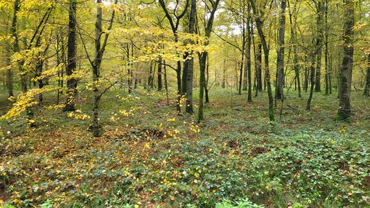
At the hashpoint
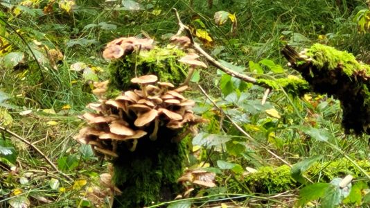
The hashpoint was located directly next to a dilapidated perch (raised hide). The surrounding wetland forest was lush with the colors of autumn and had a really comforting level of unkemptness. Everything was wet and muddy but still brimming with live. From the mushrooms to the underbrush to the tall trees and the singing birds. After taking the prerequistite photos we attempted to make our way out of the maze of ditches, thickets and dense patches of trees taking a different route than coming in to the hashpoint.
Way back
The way back to a decent path was even more difficult than the way in to the hashpoint was. At several points we were just a few meters form getting out, but an insurmountable thicket or an unjumpable ditch was in our way and we had to find a different way around. Finally we managed to get back onto a proper path and then it was just a short walk back to the car.
We were very lucky that we were able to park this close to the hashpoint because those last meters took a lot longer than we had anticipated. In the end we took around the same time (1h) as if we had walked from Wagshurst proper with no issues reaching the hashpoint itself (which was our initial assumption).
Photos
Missing path

Stupid Grins™
Proof

Panorama at the hashpoint
Mushrooms seen from hashpoint

View from the parking spot


Tracklog