Difference between revisions of "2024-10-23 64 25"
(Created page with "{{subst:expedition}}") |
|||
| Line 1: | Line 1: | ||
| − | + | {{meetup graticule|date=2024-10-23|lat=64|lon=25}} | |
| + | == Location == | ||
| + | In a meadow in Ylikylä, Kempele. | ||
| − | [ | + | The point on a topographic map: [https://kripakko.neocities.org/geohash_maplink?{{#replace:{{SUBPAGENAME}}| |_}}K] |
| − | + | == Participants == | |
| − | + | *[[User:Kripakko|Kripakko]] | |
| − | + | == Expedition == | |
| − | + | I went cycling after work. | |
| − | + | This hashpoint was in an accessible place and within a reasonable distance. | |
| − | + | The area that looked like a field or a meadow in maps and aerial photos | |
| + | would probably be legal to access | ||
| + | since nothing valuable should be growing there this late in the autumn. | ||
| − | + | I cycled from Oulu to Kempele and visited a few geocaches on the way. | |
| − | + | I tried to find a somewhat straight route via cycleways and small roads, | |
| − | + | but navigating using the GPS receiver’s tiny screen was difficult, | |
| + | and I ended up taking a few suboptimal turns. | ||
| + | Eventually, without much difficulty, I reached the edge of the meadow. | ||
| + | Only some grass had been growing in it and were already dying, | ||
| + | so I could just walk on it. | ||
| + | I reached the hashpoint at 6 pm, and there was just barely enough daylight | ||
| + | for taking acceptable photos. | ||
| + | The sun had set half an hour earlier, and thereafter it got dark fast. | ||
| + | I did not feel like taking more photos because there was not much interesting to see | ||
| + | and because the low light made photography difficult. | ||
| − | + | Some 30 minutes later it was pretty much dark, | |
| − | + | and I cycled home in the lights of the street lamps. | |
| + | According to the GPS receiver, I cycled 33.5 km and walked 0.3 km in total. | ||
| − | == | + | == Tracklog == |
| − | + | I cut parts of the tracklog where I visited a mystery geocache and a multicache | |
| + | so that I would not reveal their final locations. | ||
| − | + | {{tracklog|2024-10-23 64 25 tracklog.gpx}} | |
| − | |||
== Photos == | == Photos == | ||
| − | < | + | <gallery perrow="4"> |
| − | Image:2024- | + | Image:2024-10-23 64 25 01-bicycle.jpg|Where I left the bicycle and continued on foot, about 90 metres to go. |
| − | -- | + | Image:2024-10-23 64 25 02-gpsr1.jpg|Proof of location. |
| − | + | Image:2024-10-23 64 25 03-gpsr2.jpg|Proof of date and time. | |
| + | Image:2024-10-23 64 25 04-selfie.jpg|Stupid Grin™ | ||
</gallery> | </gallery> | ||
== Achievements == | == Achievements == | ||
| − | {{ | + | {{Land geohash | name = [[User:Kripakko|Kripakko]] | latitude = 64 | longitude = 25 | date = 2024-10-23}} |
| − | + | {{Bicycle geohash | name = [[User:Kripakko|Kripakko]] | latitude = 64 | longitude = 25 | date = 2024-10-23 | distance = 33.5 km | bothways = true}} | |
__NOTOC__ | __NOTOC__ | ||
| − | |||
| − | |||
| − | |||
| − | |||
| − | |||
| − | |||
| − | |||
| − | |||
| − | |||
[[Category:Expeditions]] | [[Category:Expeditions]] | ||
| − | |||
[[Category:Expeditions with photos]] | [[Category:Expeditions with photos]] | ||
| − | |||
| − | |||
| − | |||
| − | |||
[[Category:Coordinates reached]] | [[Category:Coordinates reached]] | ||
| − | |||
| − | |||
| − | |||
| − | |||
| − | |||
| − | |||
| − | |||
| − | |||
| − | |||
| − | |||
| − | |||
| − | |||
| − | |||
| − | |||
Revision as of 19:55, 23 October 2024
| Wed 23 Oct 2024 in 64,25: 64.8879925, 25.5668473 geohashing.info google osm bing/os kml crox |
Location
In a meadow in Ylikylä, Kempele.
The point on a topographic map: [1]
Participants
Expedition
I went cycling after work. This hashpoint was in an accessible place and within a reasonable distance. The area that looked like a field or a meadow in maps and aerial photos would probably be legal to access since nothing valuable should be growing there this late in the autumn.
I cycled from Oulu to Kempele and visited a few geocaches on the way. I tried to find a somewhat straight route via cycleways and small roads, but navigating using the GPS receiver’s tiny screen was difficult, and I ended up taking a few suboptimal turns. Eventually, without much difficulty, I reached the edge of the meadow. Only some grass had been growing in it and were already dying, so I could just walk on it. I reached the hashpoint at 6 pm, and there was just barely enough daylight for taking acceptable photos. The sun had set half an hour earlier, and thereafter it got dark fast. I did not feel like taking more photos because there was not much interesting to see and because the low light made photography difficult.
Some 30 minutes later it was pretty much dark, and I cycled home in the lights of the street lamps. According to the GPS receiver, I cycled 33.5 km and walked 0.3 km in total.
Tracklog
I cut parts of the tracklog where I visited a mystery geocache and a multicache so that I would not reveal their final locations.
Photos
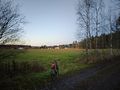
Where I left the bicycle and continued on foot, about 90 metres to go.

Proof of location.

Proof of date and time.

Stupid Grin™


Achievements
Kripakko earned the Land geohash achievement
|
Kripakko earned the Bicycle geohash achievement
|