Difference between revisions of "2008-06-21 32 -86"
From Geohashing
imported>ReletBot m (Failed => Not reached) |
imported>Jiml m (Appease APBot) |
||
| Line 1: | Line 1: | ||
{{meetup graticule | {{meetup graticule | ||
| − | |||
| lat=32 | | lat=32 | ||
| lon=-86 | | lon=-86 | ||
| Line 8: | Line 7: | ||
}} | }} | ||
| − | == | + | == Location == |
| + | A few hundred feet from Hwy 145 | ||
| − | == | + | == Participants == |
| − | [[Image:21Jun08GPS.jpg|left|thumbnail|Got close. From Highway 145, I was able to get the correct Latitude, but the Longitude was off by a couple hundred feet into VERY dense forest, and beyond the ditch I could see a fence, so it was someone's fenced land. | + | * [[User:N76lima|N76lima]] |
| + | |||
| + | ==Expedition== | ||
| + | |||
| + | |||
| + | |||
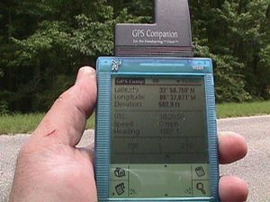
| + | [[Image:21Jun08GPS.jpg|left|thumbnail|Got close. ]] | ||
| + | |||
| + | From Highway 145, I was able to get the correct Latitude, but the Longitude was off by a couple hundred feet into VERY dense forest, and beyond the ditch I could see a fence, so it was someone's fenced land. | ||
[[Category:Expeditions]] | [[Category:Expeditions]] | ||
Revision as of 07:37, 1 June 2010
| Sat 21 Jun 2008 in Montgomery: 32.9793177, -86.6139621 geohashing.info google osm bing/os kml crox |
Location
A few hundred feet from Hwy 145
Participants
Expedition
From Highway 145, I was able to get the correct Latitude, but the Longitude was off by a couple hundred feet into VERY dense forest, and beyond the ditch I could see a fence, so it was someone's fenced land.
