Difference between revisions of "2008-09-07 40 -74"
From Geohashing
imported>Jevanyn |
imported>Jevanyn |
||
| Line 23: | Line 23: | ||
Image:20080907 40 -74 dino.JPG|We later discovered this dinosaur chained up outside a diner. | Image:20080907 40 -74 dino.JPG|We later discovered this dinosaur chained up outside a diner. | ||
</gallery> | </gallery> | ||
| − | |||
| − | |||
| − | |||
| − | |||
[[Category:Expeditions]] | [[Category:Expeditions]] | ||
| Line 32: | Line 28: | ||
[[Category:Coordinates not reached]] | [[Category:Coordinates not reached]] | ||
[[Category:Failed - No public access]] | [[Category:Failed - No public access]] | ||
| − | |||
Revision as of 16:02, 13 February 2009
| Sun 7 Sep 2008 in Newark, New Jersey: 40.2259222, -74.1526692 geohashing.info google osm bing/os kml crox |
Planning
- Jevanyn: Coming back from Cape May via the Parkway, we're making a side trip to Earle to find the geohash. It's just off Route 33 to the south, near the Naval Weapons test grounds. I've posted to Facebook to see if any other Newark geohashers can make it.
Execution
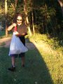
Stopped in Earle on the way home from visiting Cape May. Side of Route 33 featured No Tresspassing signs and poison ivy. Took pictures and picked up trash. Uncovered dinosaur abuse; called ASPCA.
Proof
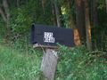
A mailbox on the site.
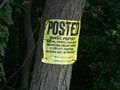
The neighboring lot is owned by Eagle Oaks Golf Course, just to the south.
Clearly, the folks at the golf course are too busy to clean up their property....
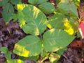
This is what poison ivy looks like up close

This is what a velociraptor attack looks like!
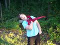
It bit my wife, too.
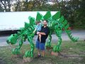
We later discovered this dinosaur chained up outside a diner.


