Difference between revisions of "2008-10-08 49 9"
imported>Danatar (page created) |
imported>Danatar (added midnight expedition) |
||
| Line 6: | Line 6: | ||
| graticule_name=Würzburg | | graticule_name=Würzburg | ||
| graticule_link=Würzburg, Germany | | graticule_link=Würzburg, Germany | ||
| − | }} | + | }}__NOTOC__ |
| − | __NOTOC__ | ||
== Location == | == Location == | ||
| − | Today's location is in a vineyard on the outskirts of Würzburg. It's mostly for white wine but there are also a few rows of red grapes. | + | Today's location is in a vineyard on the outskirts of Würzburg. It's mostly for white wine but there are also a few rows of red grapes. The different vineyards' owners seem to be the Juliusspital (founded 1579) and the Bürgerspital zum Heiligen Geist (founded 1316). |
== Expedition== | == Expedition== | ||
===[[User:Danatar|Danatar]]=== | ===[[User:Danatar|Danatar]]=== | ||
| − | ====Déja | + | ====Déja-vu Expedition==== |
| − | As the hashpoint is only 4 km linear distance from my home, I decided to go for the déja vu, walk and midnight achievements. I had never been to that vineyard, so I had to go there before 2008-10-08 for the déja vu to take effect. I took the bus until [http://maps.google.com/?ie=UTF8&q=loc:49.771,9.9575&ll=49.770996,9.957497&spn=0.007525,0.019312&z=16 Hans-Löffler-Straße bus stop], then climbed down to the hashpoint. I marked the hashpoint and on the track next to it my future presence, took some pictures to | + | As the hashpoint is only 4 km linear distance from my home, I decided to go for the déja-vu, walk and midnight achievements. I had never been to that vineyard, so I had to go there before 2008-10-08 for the déja-vu to take effect. I took the bus until [http://maps.google.com/?ie=UTF8&q=loc:49.771,9.9575&ll=49.770996,9.957497&spn=0.007525,0.019312&z=16 Hans-Löffler-Straße bus stop], then climbed down to the hashpoint. I marked the hashpoint and on the track next to it my future presence, took some pictures to prove the déja-vu and returned, also by bus. |
====Official Expedition==== | ====Official Expedition==== | ||
| − | Planning: I will walk there, using Randersackerer Straße and arrive at midnight. At | + | <strike>Planning: I will walk there, using Randersackerer Straße and I'll arrive at midnight. At 00:19 the last bus will start at Hans-Löffler-Straße and to get there it takes 8 minutes, so I won't have much time. As I already marked the hashpoint, I will not have to search long for it.</strike> |
| + | |||
| + | Walking went well, but I took another road because Randersackerer Straße partly had no sidewalk. I reached the track next to the hashpoint at 23:50 and got within one meter of my chalk mark without needing the torch (I'm good at finding previously known locations again). I waited there until 23:59, then took the last steps between the rows of vines. After taking the usual pictures I again climbed the vineyard to Hans-Löffler-Straße and took the 00:19 bus. | ||
| + | |||
<gallery perrow="4"> | <gallery perrow="4"> | ||
| Line 24: | Line 26: | ||
Image:2008-10-08 49 9 a4tiwh.jpg|3) The internet will be here. Tonight. | Image:2008-10-08 49 9 a4tiwh.jpg|3) The internet will be here. Tonight. | ||
Image:2008-10-08 49 9 heidingsfeld.jpg|4) On the other side of the river Main you can see Heidingsfeld, on of Würzburg's districts. | Image:2008-10-08 49 9 heidingsfeld.jpg|4) On the other side of the river Main you can see Heidingsfeld, on of Würzburg's districts. | ||
| − | 5) | + | Image:2008-10-08 49 9 b5hp.jpg|5) Wednesday, 2008-10-08 00:00, coordinates reached. No sun, some clouds, 13.9°C |
| − | 6) | + | Image:2008-10-08 49 9 b6mark.jpg|6) That's funny, now the chalk is visible and the sticks are not. |
| − | 7) | + | Image:2008-10-08 49 9 b7tiwh.jpg|7) The internet was here. |
| − | 8) | + | Image:2008-10-08 49 9 b8heidingsfeld.jpg|8) On the other side of the invisible river you cannot see Heidingsfeld. (Picture taken from same place as 4) |
Image:2008-10-08 49 9 a1overview.jpg|The vineyard, hashpoint marked. | Image:2008-10-08 49 9 a1overview.jpg|The vineyard, hashpoint marked. | ||
| + | Image:2008-10-08 49 9 blume.jpg|These plants are growing among the vines. | ||
Image:2008-10-08 49 9 busstop.jpg|Hans-Löffler-Straße bus stop (line 6) | Image:2008-10-08 49 9 busstop.jpg|Hans-Löffler-Straße bus stop (line 6) | ||
| − | Image:2008-10-08 49 9 | + | Image:2008-10-08 49 9 bus.jpg|Last bus for the day. Or, to be exact, the first one. |
</gallery> | </gallery> | ||
| − | + | I walked all the way to the hashpoint (no photo), arrived at midnight (pictures 5-8, especially 5) and I was there before (all daylight photos, especially 1). | |
| − | |||
| − | I walked to the hashpoint (no photo), arrived at midnight (pictures 5-8, especially 5) and I was there before (all daylight photos, especially 1) | ||
| − | There is no Déja | + | There is no Déja-vu Ribbon yet :-( |
| − | {{Midnight geohash | latitude = 49 | longitude = 9 | date = 2008-10-08 | name = [[User:Danatar|Danatar]] | image = | + | {{Midnight geohash | latitude = 49 | longitude = 9 | date = 2008-10-08 | name = [[User:Danatar|Danatar]] | image = 2008-10-08_49_9_b5hp.jpg }}{{ |
| − | {{Walk geohash | latitude = 49 | longitude = 9 | date = 2008-10-08 | name = [[User:Danatar|Danatar]] | distance = | + | Walk geohash | latitude = 49 | longitude = 9 | date = 2008-10-08 | name = [[User:Danatar|Danatar]] | distance = 6.1 km}} |
[[Category:Expeditions]] | [[Category:Expeditions]] | ||
[[Category:Expeditions with photos]] | [[Category:Expeditions with photos]] | ||
[[Category:Expedition without GPS]] | [[Category:Expedition without GPS]] | ||
| − | [[Category:Coordinates reached]] | + | [[Category:Coordinates reached]] |
Revision as of 23:16, 7 October 2008
| Wed 8 Oct 2008 in Würzburg: 49.7698993, 9.9606956 geohashing.info google osm bing/os kml crox |
Location
Today's location is in a vineyard on the outskirts of Würzburg. It's mostly for white wine but there are also a few rows of red grapes. The different vineyards' owners seem to be the Juliusspital (founded 1579) and the Bürgerspital zum Heiligen Geist (founded 1316).
Expedition
Danatar
Déja-vu Expedition
As the hashpoint is only 4 km linear distance from my home, I decided to go for the déja-vu, walk and midnight achievements. I had never been to that vineyard, so I had to go there before 2008-10-08 for the déja-vu to take effect. I took the bus until Hans-Löffler-Straße bus stop, then climbed down to the hashpoint. I marked the hashpoint and on the track next to it my future presence, took some pictures to prove the déja-vu and returned, also by bus.
Official Expedition
Planning: I will walk there, using Randersackerer Straße and I'll arrive at midnight. At 00:19 the last bus will start at Hans-Löffler-Straße and to get there it takes 8 minutes, so I won't have much time. As I already marked the hashpoint, I will not have to search long for it.
Walking went well, but I took another road because Randersackerer Straße partly had no sidewalk. I reached the track next to the hashpoint at 23:50 and got within one meter of my chalk mark without needing the torch (I'm good at finding previously known locations again). I waited there until 23:59, then took the last steps between the rows of vines. After taking the usual pictures I again climbed the vineyard to Hans-Löffler-Straße and took the 00:19 bus.
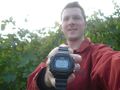
1) Tuesday, 2008-10-07 17:34 at the hashpoint.
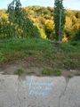
2) Can anybody see the smaller "xkcd" on the stone in blue chalk?
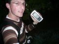
3) The internet will be here. Tonight.
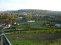
4) On the other side of the river Main you can see Heidingsfeld, on of Würzburg's districts.
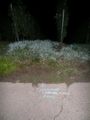
5) Wednesday, 2008-10-08 00:00, coordinates reached. No sun, some clouds, 13.9°C
6) That's funny, now the chalk is visible and the sticks are not.
7) The internet was here.
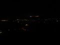
8) On the other side of the invisible river you cannot see Heidingsfeld. (Picture taken from same place as 4)
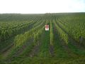
The vineyard, hashpoint marked.
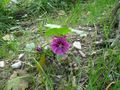
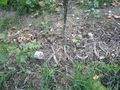
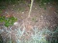
These plants are growing among the vines.
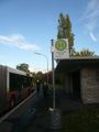
Hans-Löffler-Straße bus stop (line 6)
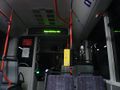
Last bus for the day. Or, to be exact, the first one.


I walked all the way to the hashpoint (no photo), arrived at midnight (pictures 5-8, especially 5) and I was there before (all daylight photos, especially 1).
There is no Déja-vu Ribbon yet :-(
Danatar earned the Midnight Geohash achievement
|
Danatar earned the Walk geohash Achievement
|