Difference between revisions of "2008-10-11 40 -105"
imported>Jaeger (New page: {{meetup graticule | map=<map lat="40" lon="-105" date="2008-10-11" /> | lat=40 | lon=-105 | date=2008-10-11 | graticule_name=Denver | graticule_link=Denver, Colorado}} == About == The h...) |
imported>FippeBot m (Location) |
||
| Line 23: | Line 23: | ||
[[Category:Coordinates reached]] | [[Category:Coordinates reached]] | ||
[[Category:Expeditions with photos]] | [[Category:Expeditions with photos]] | ||
| + | {{location|US|CO|BO}} | ||
Revision as of 00:16, 8 August 2019
| Sat 11 Oct 2008 in Denver: 40.1883920, -105.1468141 geohashing.info google osm bing/os kml crox |
About
The hash coordinates are in a private backyard along a major road in north-west Longmont. Geohashers unwilling to make new friends with random neighbors can stand on the sidewalk side of the fence and be within ten meters of the official coordinates.
Expeditions
Jaeger
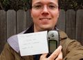
The hash coordinates were six kilometers (straight line) from my house, across Longmont. I set out shortly before noon in the light rain. (If the weather had been nicer, I would have biked, but given the rain, I drove.) The actual coordinates were just inside someone's back yard, but quite close to the fence on the south side of 17th Street. I reached the fence at 11:40 MDT and did my best to take a self-portrait. This is somewhat harder with an SLR camera; I had to aim and hope I got it right. My GPS receiver indicated I was between seven and twelve meters from the actual cache location as I took the picture. I'm counting this as "officially close enough".
As close as possible
