Difference between revisions of "2008-11-02 52 6"
imported>Arvid (initial page) |
imported>Arvid (images) |
||
| Line 25: | Line 25: | ||
Around 17:00 I was home again. | Around 17:00 I was home again. | ||
| − | |||
| − | |||
<gallery> | <gallery> | ||
| + | Image:2008-11-02 52 6-RES02132.JPG|Bike. | ||
| + | Image:2008-11-02 52 6-RES02133.JPG|Field where the hash is. | ||
| + | Image:2008-11-02 52 6-RES02135.JPG|Success! | ||
| + | Image:2008-11-02 52 6-RES02136.JPG|Me. | ||
| + | Image:2008-11-02 52 6-RES02137.JPG|More me. | ||
| + | Image:2008-11-02 52 6-RES02139.JPG|Look back to the road from the hashpoint. | ||
| + | Image:2008-11-02 52 6-RES04127.JPG|2fast4u. | ||
</gallery> | </gallery> | ||
Revision as of 18:50, 2 November 2008
| Sun 2 Nov 2008 in 52,6: 52.0616062, 6.7168737 geohashing.info google osm bing/os kml crox |
Plan
Arvid will do a nice sunday afternoon hash. Go there as fast as possible, and then take a very odd way back to get logs that he can use for Openstreetmap.
Achievements
Expedition
Arvid's tracklog by bicycle.
I left home around 14:15, and with a little backwind and a little bit of sun, I arrived at the intended place to get off my bike at 15:05. 27.2km in 51 minutes. I have done worse.
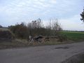
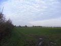
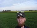
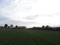
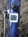
The hashpoint was in a very accessible field. After I had something to eat I walked in there. The hashpoint was about 190m off the road, so it was a little walk, but it was very easy. I made a picture of the gps at the hashpoint, and a couple of myself.
At 15:20 I was off again, taking as many roads I think are not yet in Openstreetmap as I could. Check the tracklog for details. This way back was of course considerably longer, that's why the total distance is a lot more than 2x27km.
Around 17:00 I was home again.
Bike.
Field where the hash is.
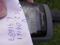
Success!
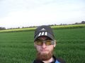
Me.
More me.
Look back to the road from the hashpoint.
2fast4u.


