Difference between revisions of "Cambridge, United Kingdom"
imported>Spanky (→Local Geohashers) |
|||
| Line 32: | Line 32: | ||
[[User:Spanky|Spanky]] suggests: some cunning way of indicating who has visited a spot...? | [[User:Spanky|Spanky]] suggests: some cunning way of indicating who has visited a spot...? | ||
| + | |||
| + | ==Mini Geohashing== | ||
| + | |||
| + | A new idea for the bike-powered. To get a location always close to the centre of Cambridge, try mini-geohashing over an area 1% of a standard graticule. | ||
| + | |||
| + | Method: find your current coordinates and remove everything after the first decimal place. In Cambridge, that's going to be either 52.1 or 52.2 north and 0.0 or 0.1 east. Then add the standard string of digits to the end of the number. | ||
| + | |||
| + | E.g. the geohash coordinates for Sunday 25th May 2008 in the standard graticule are 52.941774°, 0.182873°. That makes the mini-geohash location closest to the centre of Cambridge 52.1941774°, 0.1182873° - [http://maps.google.co.uk/maps?f=q&hl=en&geocode=&q=52.1941774%C2%B0,+0.1182873%C2%B0&ie=UTF8&ll=52.194166,0.119176&spn=0.012469,0.040169&t=h&z=15&iwloc=addr much more convenient] | ||
| + | |||
| + | What do you think? - Sarah | ||
[[Category:British Isles]] | [[Category:British Isles]] | ||
Revision as of 16:15, 26 May 2008
| - | - | - |
| Northampton | Cambridge | - |
| London West | London East | - |
[[Category:Meetup in {{{lat}}} {{{lon}}}| ]]
This graticule has boundaries from 52° to 53° latitude, and 0° to 1° longitude and contains Cambridge, UK. The graticle from -1° to 0° longitude is also near to Cambridge, but, due to the symmetry about the prime meridian, will never provide locations closer to the centre of Cambridge.
Local Geohashers
- Slainveteran is bike powered, so will only be able to make it when the coordinates lie nearby Cambridge itself
- lilac is also bike powered, but might be prepared to cycle up to about ten miles for a Saturday location.
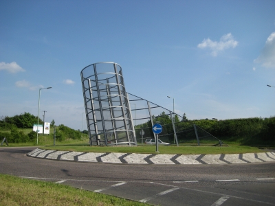
- Spanky is also bike powered, and went Saturday (24/5), leaving a little later than expected. Saw nobody and will be taking a satnav in future. Here is an Art found outside Haverhill:
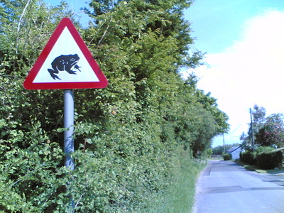
- youpi is bike powered, was there (52.126648°, 0.547533°) this afternoon (Saturday, 24/5) between 16:00 and 16:30 but saw nobody :/ Anyway it was a cool 46 miles tour! On the way I spotted an unexpected road sign:
For the cycle-powered, Sunday's location (2008-05-25) looks to be reachable from Bishops Stortford / Stansted Airport railway stations (though it's about 10 miles each way):
51.9417748528,0.18287359767
Mmm, it looks like there is a mistake above: it is *not* in the (52,0) graticule...
- True, but the (52,0) location is further from Cambridge, and significantly more underwater.
Spanky suggests: some cunning way of indicating who has visited a spot...?
Mini Geohashing
A new idea for the bike-powered. To get a location always close to the centre of Cambridge, try mini-geohashing over an area 1% of a standard graticule.
Method: find your current coordinates and remove everything after the first decimal place. In Cambridge, that's going to be either 52.1 or 52.2 north and 0.0 or 0.1 east. Then add the standard string of digits to the end of the number.
E.g. the geohash coordinates for Sunday 25th May 2008 in the standard graticule are 52.941774°, 0.182873°. That makes the mini-geohash location closest to the centre of Cambridge 52.1941774°, 0.1182873° - much more convenient
What do you think? - Sarah

