Difference between revisions of "2009-01-14 35 -77"
From Geohashing
imported>Ncbears |
imported>Ncbears (→Achievements) |
||
| Line 37: | Line 37: | ||
Image:Landgeohash.png|[[Land Geohash]] | Image:Landgeohash.png|[[Land Geohash]] | ||
Image:Cherry2.PNG|[[Virgin Graticule]] | Image:Cherry2.PNG|[[Virgin Graticule]] | ||
| − | + | Image:NCBearsxkcdregion3.png|[[Minesweeper_Geohash|Minesweeper Level 3]] | |
</gallery> | </gallery> | ||
Revision as of 00:38, 15 January 2009
| Wed 14 Jan 2009 in 35,-77: 35.8578152, -77.8131697 geohashing.info google osm bing/os kml crox |
Report
Participants
Eisen & Bear - NCBears
Geological Features
Rolling farmland (mostly corn and cotton crops, and cattle and horse farms). Geohash was located ~5 meters inside wooded area, about 375 meters from Lake Gaston, and 4.0 miles/6.5 km south of the Virginia border. Open field between Geohash and road was used for corn crop. See Google Earth screenshot below.
Wildlife Encounters
- See picture below of wild-life signs
Weather
33°F/0.6°C, clear skies
Pictures
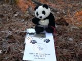
NCBears at N36 W77 Meetup near Lake Gaston, NC

Achievements
- NCBearsxkcdregion3.png

