Difference between revisions of "2009-01-17 49 -123"
imported>Thepiguy (New page: {{meetup graticule | map=<map lat="49" lon="-123" date="2009-01-17" /> | lat=49 | lon=-123 | date=22009-01-17 | graticule_name=Vancouver | graticule_link=Vancouver, British Columbia }} [[u...) |
imported>Thepiguy m (Date error) |
||
| Line 3: | Line 3: | ||
| lat=49 | | lat=49 | ||
| lon=-123 | | lon=-123 | ||
| − | | date= | + | | date=2009-01-17 |
| graticule_name=Vancouver | | graticule_name=Vancouver | ||
| graticule_link=Vancouver, British Columbia | | graticule_link=Vancouver, British Columbia | ||
Revision as of 18:12, 11 February 2009
| Sat 17 Jan 2009 in Vancouver: 49.3238594, -123.1391970 geohashing.info google osm bing/os kml crox |
thepiguy made his first hash of the new year by cycling to North-Vancouver in the fog.
Contents
Location
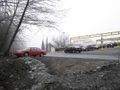
In the parking lot of the Park Royal shopping center.
Expedition
Save the apocalyptic fog, this was a pretty standard bicycle hash. I knew the exact rout I had to take (see below) and managed to get there in decent time (considering I've been biking less than 15km a week as of late). I ended up meeting up with a friend on the way back, so I only cycled 3/5 of the actual distance.
Déjà Vu Geohash
As soon as I saw the location, I immediately knew I qualified for the Déjà Vu achievement. It was on the exact rout I use to access the Horseshoe Bay ferry terminal. The only question was: how do I prove it? Then I remembered I have the entire tracklog from my 2008-09-01 expedition saved, and that it shows me passing directly by it! Achievement achieved!
Images
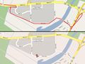
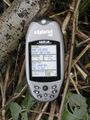
Tracklog on the top, geohash on the bottom!
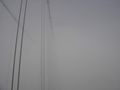
This is what Vancouver looked like from Richmond.
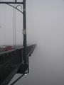
This is what it was like on the Lions Gate bridge.
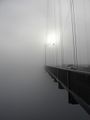
So. Very. Creepy.
Looking up a little bit.
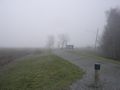
The ever-so-lovely parking lot shot.
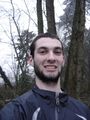
Oh dear lord, I need shave that terrible sudo-mustache.
Can't have enough of these.


