Difference between revisions of "2009-02-09 67 20"
From Geohashing
imported>The ru m (wrong caps) |
imported>The ru |
||
| Line 36: | Line 36: | ||
[[Category:Expeditions]] | [[Category:Expeditions]] | ||
[[Category:Expeditions with photos]] | [[Category:Expeditions with photos]] | ||
| − | |||
Revision as of 08:16, 10 February 2009
| Mon 9 Feb 2009 in 67,20: 67.8956375, 20.4976079 geohashing.info google osm bing/os kml crox |
The hashpoint was in the forest, 200 m from the Kallovaara road near Jukkasjärvi.
the ru
A rather easy hash. My mother and her dog accompanied me in the car but didn't follow me to the hash. There wasn't really a lot to see there though, since it was dark and snowing. Lots of reindeer tracks about.
... and when I got home, I discovered I had lost a glove. I had to drive back the whole way (7 km) to retrieve it.
the ru earned the Consecutive geohash achievement
|
the ru earned the Land geohash achievement
|
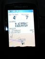
Didn't bother to get a closer reading than this - got within 2 m at best
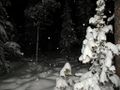
- 2009-02-09 67 20 snow.jpg
Sad geohasher in snow
- 2009-02-09 67 20 disa.jpg
Disa the cocker spaniel was afraid of the dark and was eager to get back into the car
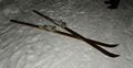
My skis
- 2009-02-09 67 20 car.jpg
On the way back


