Difference between revisions of "2009-02-23 52 -7"
imported>Benjw m (→Expedition: typo) |
imported>Brandon m |
||
| Line 25: | Line 25: | ||
| longitude = -7 | | longitude = -7 | ||
| date = 2009-02-23 | | date = 2009-02-23 | ||
| − | | name = JRK | + | | name = [[User:JRK|JRK]] |
}} | }} | ||
| Line 32: | Line 32: | ||
| longitude = -7 | | longitude = -7 | ||
| date = 2009-02-23 | | date = 2009-02-23 | ||
| − | | name = JRK | + | | name = [[User:JRK|JRK]] |
}} | }} | ||
| Line 39: | Line 39: | ||
| longitude = -7 | | longitude = -7 | ||
| date = 2009-02-23 | | date = 2009-02-23 | ||
| − | | name = JRK | + | | name = [[User:JRK|JRK]] |
}} | }} | ||
[[Category:Expeditions with photos]] | [[Category:Expeditions with photos]] | ||
[[Category:Coordinates reached]] | [[Category:Coordinates reached]] | ||
Revision as of 23:04, 23 February 2009
| Mon 23 Feb 2009 in Waterford, Ireland: 52.2835371, -7.1187077 geohashing.info google osm bing/os kml crox |
About
I was waiting for a geohash close to my place for a couple of months already (I have no car and public transport in Ireland is almost non-existant) and finally - it was generated very close to the city.
Expedition
As it was my very first expedition, I was very excited about it. I wasn't expecting grand adventure, as the destination was just an hour walk from the city, but I was positively surprised, when I found a medieval tower on my way, that I had no idea was there. The spot itself was just outside some nice looking house. In total it was 12 km of walking there and back, a little hill climbing and running for your life on the busy road without any pedestrian pavement.
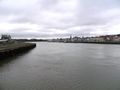
Crossing the bridge.
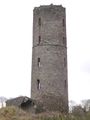
Unexpected discovery.
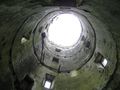
I feel dizzy.

Beware it's A FARM!
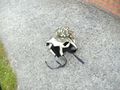
My first geohash.
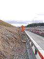
Going home and risking life.


JRK earned the Land geohash achievement
|
JRK earned the Walk geohash Achievement
|