Difference between revisions of "2009-03-02 35 -77"
From Geohashing
imported>Ncbears (New page: __NOTOC__ {{meetup graticule | map=<map lat="35" lon="-77" date="2009-03-02" /> | lat=35 | lon=-77 | date=2009-03-02 }} ==Report== Since this was one of only two snows we’ve had in over...) |
imported>FippeBot m (Location) |
||
| Line 44: | Line 44: | ||
[[Category:Expeditions with photos]] | [[Category:Expeditions with photos]] | ||
[[Category:Coordinates reached]] | [[Category:Coordinates reached]] | ||
| + | {{location|US|NC|ED}} | ||
Latest revision as of 02:13, 6 August 2019
| Mon 2 Mar 2009 in 35,-77: 35.7978503, -77.5216351 geohashing.info google osm bing/os kml crox |
Report
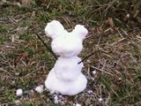
Since this was one of only two snows we’ve had in over 4 years, we took advantage of the situation and attempted a Snowman Geohash. We left right after work, so we didn’t have our GPS, good camera, or other trappings. But, we used map printouts to find the Geohash on the side of a road.
We figured there would be very little snow east of us (and there wasn’t), so I filled up a cooler with snow outside my office during lunch.
Participants
Geological Features
Flat farmland. On side of road, 6 miles/10km south of Tarboro, NC.
Wildlife Encounters
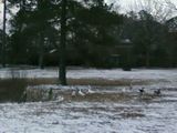
Sightings - Geese, cows, chickens, domestic dogs.
Weather
32°F/0°C, cloudy.


