Difference between revisions of "2009-03-14 41 -73"
From Geohashing
imported>Rgrossi (New page: {{meetup graticule | map=<map lat="41" lon="-73" date="2009-03-14" /> | lat=41 | lon=-73 | date=2009-03-14 | graticule_name=Danbury, Connecticut | graticule_link=Danbury, Connecticut }} =...) |
imported>Rgrossi (→Pictures) |
||
| Line 15: | Line 15: | ||
==Pictures== | ==Pictures== | ||
| − | <gallery widths=" | + | <gallery widths="150px" heights="160px" perrow="3"> |
Image:2009-03-14 41 -73 p1.jpg|Map of the geohash location | Image:2009-03-14 41 -73 p1.jpg|Map of the geohash location | ||
Image:2009-03-14 41 -73 p2.jpg|Looking east from the location | Image:2009-03-14 41 -73 p2.jpg|Looking east from the location | ||
Revision as of 14:59, 16 March 2009
| Sat 14 Mar 2009 in Danbury, Connecticut: 41.5407367, -73.1119046 geohashing.info google osm bing/os kml crox |
The Location
The town of Middlebury, Connecticut, in the middle of Carriage Drive.
The Geohash
Ryan went to the location at about 4:30 PM EDT. My phone showed me directly at the location, but when I got home and checked the map online it showed the location about 750 feet to the east.
Pictures

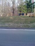
Map of the geohash location
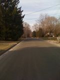
Looking east from the location
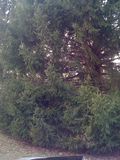
Looking north from the location
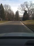
Looking west from the location
Looking south from the location


