Difference between revisions of "2009-03-21 30 -86"
imported>Bos (→Photos) |
imported>Bos (→Photos) |
||
| Line 29: | Line 29: | ||
Image:2009-03-21 30 -86-Track.jpg|West track ingress, east egress. Final 250 meters brutal. | Image:2009-03-21 30 -86-Track.jpg|West track ingress, east egress. Final 250 meters brutal. | ||
Image:2009-03-21 30 -86-GoodStart.jpg|Initial trail easy | Image:2009-03-21 30 -86-GoodStart.jpg|Initial trail easy | ||
| − | Image:2009-03-21 30 -86-Blood.jpg|Early blood - got worse before reaching hash | + | <!---Image:2009-03-21 30 -86-Blood.jpg|Early blood - got worse before reaching hash ---> |
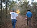
| + | Image:2009-03-21 30 -86-Raptor.jpg|Defensive wounds - WARNING Velociraptors | ||
Image:2009-03-21 30 -86-Fireants.jpg|Plenty here. We learn fast to avoid them. | Image:2009-03-21 30 -86-Fireants.jpg|Plenty here. We learn fast to avoid them. | ||
Image:2009-03-21 30 -86-Inpenetratable.jpg|Not quite inpenetrable brush. | Image:2009-03-21 30 -86-Inpenetratable.jpg|Not quite inpenetrable brush. | ||
| − | Image:2009-03-21 30 -86-L-P-GPS.jpg|Broke into small clearing reaching the hash | + | <!---Image:2009-03-21 30 -86-L-P-GPS.jpg|Broke into small clearing reaching the hash ---> |
| + | Image:2009-03-21 30 -86-GPS.jpg|Thirty four minutes late - Delayed by hostile vegetation | ||
Image:2009-03-21 30 -86-L-P-Hash.jpg|Liberian's Gatoraid very welcome | Image:2009-03-21 30 -86-L-P-Hash.jpg|Liberian's Gatoraid very welcome | ||
Image:2009-03-21 30 -86-Catcus.jpg|Powertool shows Liberian attack cactus - note long shadows | Image:2009-03-21 30 -86-Catcus.jpg|Powertool shows Liberian attack cactus - note long shadows | ||
Revision as of 17:09, 22 March 2009
| Sat 21 Mar 2009 in [[|]]: 30.7980280, -86.4404097 geohashing.info google osm bing/os kml crox |
Planning
In pretty dense trees about 1 KM from Poverty Creek Rd. Looks like open field to within 200 meters of the hash. Liberian, Powertool and Bos will try for 1700 meetup. --Bos 19:26, 21 March 2009 (UTC)
Expedition Report
Liberian
Both locations this weekend are on land in apparently accessible areas. Bos, Power Tool, and Liberian met up in Niceville at 3:00 (the meet-up time being 5:00 in this graticule) and headed north towards Crestview and the meet-up location. They took in three geocaches around Bob Sikes Airport on the way up but found no opportunity to "commit aviation," to use Bos' term. Heading east along Poverty Creek Road to a point north of the location, where the maps showed a faint road going south. A friendly local came over to ask what they were doing and Bos explained ("You know the game where pilots throw a dart at a map and then go fly to the place where it sticks?"). They invited the local man to join them but he declined, wishing them luck and mentioning that they should look out for the gators. And then into the forest it was; the faint road on the map was nowhere to be found. After about a quarter of a mile through thick undergrowth they came upon a wide open area which they followed for another good quarter of a mile. Then it was into the thick undergrowth again for the final quarter mile. Liberian and Power Tool got separated from Bos by a few hundred feet and were at the point of giving up 300 feet northeast of the location. They stopped to listen for Bos and heard him making steady progress to their west. They called out to him asking how he was doing and he said he was about 100 feet from the location and making progress. Power Tool and Liberian backtracked a bit, bushwhacked west to catch up with Bos, and the three of them all arrived at the meet-up location around 5:30. "Gentlemen, this calls for a celebration," said Liberian, and broke out three bottles of Gator-Ade. That was as close as the group came to gators that afternoon. After taking photographic proof for the Velociraptor Award (giving blood while on a geohash), they realized that the sun was starting to go down and they still had to get back to the road. After another quarter-mile through the thick undergrowth (easier this time, since they weren't aiming for a specific point), they came out to the clear area and followed it half a mile east to the road. Half a mile later they were back at Bos' van and picking up two more geocaches on the way home.
Photos
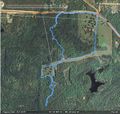
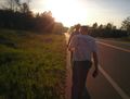
West track ingress, east egress. Final 250 meters brutal.
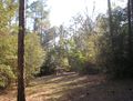
Initial trail easy
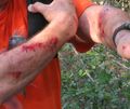
Defensive wounds - WARNING Velociraptors
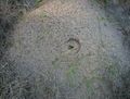
Plenty here. We learn fast to avoid them.
- 2009-03-21 30 -86-Inpenetratable.jpg
Not quite inpenetrable brush.
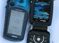
Thirty four minutes late - Delayed by hostile vegetation
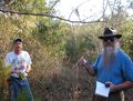
Liberian's Gatoraid very welcome
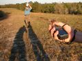
Powertool shows Liberian attack cactus - note long shadows
Took this shortcut so we could be together longer
Last 1/4 mile west on paved road


