Difference between revisions of "2009-03-29 32 -110"
From Geohashing
imported>Wyle & RoadRunner (New page: {{meetup graticule | map=<map lat="32" lon="-110" date="2009-03-29" /> | lat=32 | lon=-110 | date=2009-03-29 | graticule_name=Tucson | graticule_link=Tucson, Arizona}} == Expeditions == Lo...) |
imported>Wyle & RoadRunner |
||
| Line 10: | Line 10: | ||
<gallery widths="160px" align=center> | <gallery widths="160px" align=center> | ||
| − | Image:2009-03- | + | Image:2009-03-29_32_-110_cows.jpg|Tucson, Arizona |
| − | Image:2009-03- | + | Image:2009-03-29_32_-110_dest.jpg|Tucson, Arizona |
</gallery> | </gallery> | ||
Revision as of 17:10, 30 March 2009
| Sun 29 Mar 2009 in Tucson: 32.6765237, -110.8240546 geohashing.info google osm bing/os kml crox |
Expeditions
Locked gate along the pipeline easement didn't discourage us. It just meant a longer hike. Try explaining internet, xkcd and geohashing to cows though.
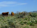
Tucson, Arizona

Tucson, Arizona

