Difference between revisions of "2008-09-26 46 13"
From Geohashing
imported>Faina09 |
imported>Faina09 |
||
| Line 5: | Line 5: | ||
}} | }} | ||
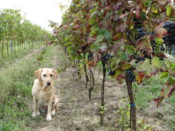
| − | Faina09 contributed this intriguing image to the photo gallery for this date but left no expedition report. I've marked it as reaching the coordinates, because Google Maps shows this day's point as being in a field quite near a road, and why would you stop and photograph a dog ''halfway'' into a vineyard unless it was at the geohash? Either you get to your destination or you photograph the fence or other barrier that stopped you. | + | [[user:Faina09|Faina09]] contributed this intriguing image to the photo gallery for this date but left no expedition report. I've marked it as reaching the coordinates, because Google Maps shows this day's point as being in a field quite near a road, and why would you stop and photograph a dog ''halfway'' into a vineyard unless it was at the geohash? Either you get to your destination or you photograph the fence or other barrier that stopped you. |
[[Image:FirstGeohash20090926.JPG|350px]] | [[Image:FirstGeohash20090926.JPG|350px]] | ||
Revision as of 18:14, 27 September 2009
| Fri 26 Sep 2008 in 46,13: 46.1228198, 13.3603035 geohashing.info google osm bing/os kml crox |
Faina09 contributed this intriguing image to the photo gallery for this date but left no expedition report. I've marked it as reaching the coordinates, because Google Maps shows this day's point as being in a field quite near a road, and why would you stop and photograph a dog halfway into a vineyard unless it was at the geohash? Either you get to your destination or you photograph the fence or other barrier that stopped you.
I hope Faina returns for more geohashes with more information.
Yes it's so! I reached the point with my she-dog Grano that is always with me in my geo-expeditions. It was my first experience; I know no others geohashers so I dedicated my time to other geo-search, but I will go to geohashing more points!
