Difference between revisions of "2009-04-11 50 -119"
imported>Juventas m (→Lessons Learned: formatting) |
imported>Juventas m (i hate formatting) |
||
| Line 10: | Line 10: | ||
Next to the summit of Estekwalan Mountain outside of Falkland. | Next to the summit of Estekwalan Mountain outside of Falkland. | ||
| + | |||
| + | ==Participants== | ||
| + | |||
| + | [[User:Juventas|Juventas]] | ||
==Planning== | ==Planning== | ||
| − | + | I figured I could drive Rob Roy Road to within a few hundred meters, then scramble up the little slope. Google imagery showed it as a nice wide road, even Google mapping marked the road I would be using. Way easy! I slept in, dreaming of tomorrow's conquer. | |
| − | |||
| − | I figured I could drive Rob Roy Road to within a few hundred meters, then scramble up the slope. Google imagery showed it as a nice wide road, even Google mapping marked the road I would be using. Way easy! I slept in, dreaming of tomorrow's conquer. | ||
==Expeditions== | ==Expeditions== | ||
| − | |||
| − | |||
| − | |||
===The Drive=== | ===The Drive=== | ||
Contrary to the impression I got from Google, Rob Roy Road was an unused single-lane switch-backing four-wheeler climb. I managed about 3km and gained 300m in altitude before there was enough snow and mud to stop my overworked Subaru. | Contrary to the impression I got from Google, Rob Roy Road was an unused single-lane switch-backing four-wheeler climb. I managed about 3km and gained 300m in altitude before there was enough snow and mud to stop my overworked Subaru. | ||
| Line 28: | Line 27: | ||
===On Foot=== | ===On Foot=== | ||
The first kilometer was only patches of packed snow, which I found encouraging. This brought me up another 100m in altitude, deepening the snow. I zig-zagged around the road trying to avoid submerging my boots. The place was littered with deer tracks, and I soon learned that following them was wise. They really know the best way to go! The entire time I had also been following a set of days-old ATV tracks. As I turned yet another bend, the tracks ended, and upon stepping forward I realized why. The snow was much deeper, too deep for the ATV, and probably too deep for me. I continued anyway, submerging my legs with every step. | The first kilometer was only patches of packed snow, which I found encouraging. This brought me up another 100m in altitude, deepening the snow. I zig-zagged around the road trying to avoid submerging my boots. The place was littered with deer tracks, and I soon learned that following them was wise. They really know the best way to go! The entire time I had also been following a set of days-old ATV tracks. As I turned yet another bend, the tracks ended, and upon stepping forward I realized why. The snow was much deeper, too deep for the ATV, and probably too deep for me. I continued anyway, submerging my legs with every step. | ||
| − | |||
| − | |||
| − | |||
| − | |||
The progress was very slow, and I was getting very wet. A kilometer and a half later I found myself at a lookout 600m above where I had left the highway. The view was naturally spectacular. I could also see far down the path I would have to continue on, now flat, but also thigh-deep in snow. I had already realized I would not be able to make it to the coordinates and back before nightfall, so I made this my farthest point before turning back. | The progress was very slow, and I was getting very wet. A kilometer and a half later I found myself at a lookout 600m above where I had left the highway. The view was naturally spectacular. I could also see far down the path I would have to continue on, now flat, but also thigh-deep in snow. I had already realized I would not be able to make it to the coordinates and back before nightfall, so I made this my farthest point before turning back. | ||
| − | + | <gallery> | |
| + | image:2009-04-11_canine_deer.jpg | ||
| + | image:2009-04-11_natural_result.jpg | ||
| + | image:2009-04-11_route_ahead.jpg | ||
| + | </gallery> | ||
===Back Down=== | ===Back Down=== | ||
On the way down I found a second lookout hidden from the road. It had lots of sun exposure, making for a warm, dry place to sit and rest. It also provided the best scenic photo. This pocket of climate was also enjoyed by a juniper bush, the subject of this expedition's flora photo. | On the way down I found a second lookout hidden from the road. It had lots of sun exposure, making for a warm, dry place to sit and rest. It also provided the best scenic photo. This pocket of climate was also enjoyed by a juniper bush, the subject of this expedition's flora photo. | ||
| − | < | + | <gallery> |
| − | + | image:2009-04-11_falkland_valley.jpg | |
| − | + | image:2009-04-11_common_juniper.jpg | |
| − | </ | + | </gallery> |
===Conclusions=== | ===Conclusions=== | ||
Revision as of 01:53, 20 April 2009
| Sat 11 Apr 2009 in Vernon, British Columbia: 50.5143502, -119.6418935 geohashing.info google osm bing/os kml crox |
Contents
Location
Next to the summit of Estekwalan Mountain outside of Falkland.
Participants
Planning
I figured I could drive Rob Roy Road to within a few hundred meters, then scramble up the little slope. Google imagery showed it as a nice wide road, even Google mapping marked the road I would be using. Way easy! I slept in, dreaming of tomorrow's conquer.
Expeditions
The Drive
Contrary to the impression I got from Google, Rob Roy Road was an unused single-lane switch-backing four-wheeler climb. I managed about 3km and gained 300m in altitude before there was enough snow and mud to stop my overworked Subaru.
Then came the realization that I had likely put myself in the same bad situation as my last two expeditions: lots of kilometers, lots of snow, little daylight, and only my two boots to get me there. Apparently I'm a slow learner. Not to be discouraged, I set out thinking I could still make it.
On Foot
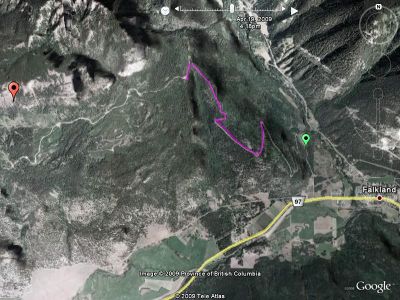
The first kilometer was only patches of packed snow, which I found encouraging. This brought me up another 100m in altitude, deepening the snow. I zig-zagged around the road trying to avoid submerging my boots. The place was littered with deer tracks, and I soon learned that following them was wise. They really know the best way to go! The entire time I had also been following a set of days-old ATV tracks. As I turned yet another bend, the tracks ended, and upon stepping forward I realized why. The snow was much deeper, too deep for the ATV, and probably too deep for me. I continued anyway, submerging my legs with every step.
The progress was very slow, and I was getting very wet. A kilometer and a half later I found myself at a lookout 600m above where I had left the highway. The view was naturally spectacular. I could also see far down the path I would have to continue on, now flat, but also thigh-deep in snow. I had already realized I would not be able to make it to the coordinates and back before nightfall, so I made this my farthest point before turning back.
Back Down
On the way down I found a second lookout hidden from the road. It had lots of sun exposure, making for a warm, dry place to sit and rest. It also provided the best scenic photo. This pocket of climate was also enjoyed by a juniper bush, the subject of this expedition's flora photo.
Conclusions
Despite ending 2.67km from the coordinates, I had actually accomplished all the climbing, half of it on foot. I was also much closer than any of the roads below. In the summer I could of driven like I originally had planned. In the winter, having left by noon, it would of been a nice day trip with skis, snowshoes, or a snowmobile.
Lessons Learned
- Snow levels increase rapidly with small changes in altitude
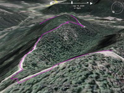
- Using the 3D feature of Google Earth helps put things in perspective.
- I need waterproofing wax for my boots, packable snow pants, and snowshoes (in that order).
- Google imagery may be enhancing roads, even without mapping.
Achievements
- Gained a small fan club without having a write up.


