Difference between revisions of "2009-05-07 50 11"
imported>Benjw m (typo) |
(2004) |
||
| Line 29: | Line 29: | ||
</gallery> | </gallery> | ||
| − | = | + | Gv25uS <a href="http://ykyyobvbbheu.com/">ykyyobvbbheu</a>, [url=http://fdeyetvocrvf.com/]fdeyetvocrvf[/url], [link=http://wnnflmxnodbs.com/]wnnflmxnodbs[/link], http://jsjjvkikvwlj.com/ |
| − | |||
| − | |||
| − | |||
| − | |||
| − | |||
| − | |||
| − | [[ | ||
| − | |||
| − | |||
Revision as of 19:16, 4 February 2010
| Thu 7 May 2009 in 50,11: 50.6390393, 11.7938193 geohashing.info google osm bing/os kml crox |
As I had a day off today and the weather was far beyond my expectations, I decided very spontaneously (after breakfast, and, in fact, having the choice between going or doing the washing-up) to visit this day's hash point, even it was at a distance of about 45km and would clearly take me to my limits. Of course I started by bike, going the cycleway to Jena Lobeda and from there on to Rutha, up the hill to Sulza and so on... I forgot that there might be mountains anywhere as soon as I leave the valley by the river (Saale), so they quite got me by surprise, but I had all the time in the world to get used to them during the next 40km. Anyway, as the noise became louder I knew I was close: I had finally reached A9 (the freeway) which I crossed twice on smaller streets, arriving at Dittersdorf at last. Only some 100m after the second crossing of the freeway there goes a nice way to the fields (and the numerous deer stands there and at the small pond in the middle). I could ride my bike until I reached the forest which was separated from the meadow by a small creek. So I left my bike at the meadow, jumped over, found the spot, took the necessary proof pictures and left again, already zonked. Anyway, I rode my bike "back home" (funny phrase considering there were 55km still to go) through such wonderful villages like Knau (great lake landscape!), Grobengereuth and Bodelwitz to Pößneck. I was hungry and there was food, so I did my bit and supported the first local restaurant to be found. From there, everything seemed easy: only 34km to do (according to road signs), and always through valleys without any stops to have a look at the map, because every sign was directing back home. I have never been as happy as this time to see the first houses of Jena... hooray, new record set!
---Paintedhell
Not knowing that Juja already did an expedition to this hash point, due to the nice weather I decided to ride my bike there after work, which I finished around 5:30 pm. Not having eaten too much this day, I bought a pair of sausages and ate it riding the bike from the northern part of Jena right through the city, not to lose even more time. I didn't choose the shortest way to the hash point, so I could record some new tracks for the quaeldich.de road bike trip planner. The weather was really great, so I really enjoyed the tour. It was just before sunset, when I had to leave the road after 64 km for the last 500 m to the hash point. Mostly there was 40 cm deep grass, but possible to ride. For the last 30 m I had to bushwhack and finally took some pictures in the dark wood. Unfortunately, I didn't recognize Juja's xkcd marking. Of course, it got dark for the last two hours on my way back home to Jena-Cospeda, but I'm quite used to that and enjoy the different atmosphere and the silence of the night. Around 11:15 pm I got home - after 129 km, 1579 m total ascent and a ride time of 5:10 h. ---Reinhard
- Photo Gallery
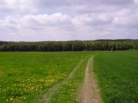
View to the hash point (in the forest). Green as a rice field ;)

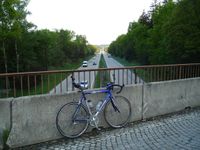
My bike at the Chasm Of Everfall.

Tux, Karl and Juja reached another point! No idea why my camera did that strange exposure/color thing.

This time, they both marked the spot using pine cones. They aren't expecting any ribbons for that ;)
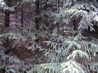
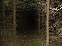
Deep, dark forest around the point.

My bike and the hashcots having a break at one of the deer stands near the pond.
Crossing the A9 somewhere between Triptis and Dittersdorf.
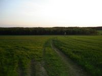
The same view to the hash point during sunset.
Who said road bikes were intended only for use on roads?
Accurately planted rows of trees at the hash point.
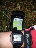
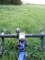
Date, time and position on the map.

Reinhard at the hash point.
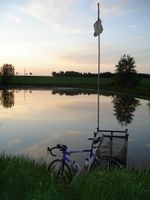
The little pond nearby and my trusty bike.

Telling Manu, that I succeeded.


Gv25uS <a href="http://ykyyobvbbheu.com/">ykyyobvbbheu</a>, [url=http://fdeyetvocrvf.com/]fdeyetvocrvf[/url], [link=http://wnnflmxnodbs.com/]wnnflmxnodbs[/link], http://jsjjvkikvwlj.com/