Difference between revisions of "2009-05-08 67 19"
From Geohashing
imported>The ru (New page: {{meetup graticule | map=<map lat="67" lon="19" date="2009-05-08" /> | lat=67 | lon=19 | date=2009-05-08 }} <gallery perrow="4"> Image:2009-05-08_67_19_gps.jpg | GPS @ the hashpoint Ima...) |
imported>The ru |
||
| Line 20: | Line 20: | ||
The area had many rather... bizarre trees. They looked like they had snapped at a young age, but kept growing and curled around themselves. They were just below the treeline, so I guess they are stretching the limits on where pinetrees are supposed to grow. | The area had many rather... bizarre trees. They looked like they had snapped at a young age, but kept growing and curled around themselves. They were just below the treeline, so I guess they are stretching the limits on where pinetrees are supposed to grow. | ||
| + | |||
| + | <gallery perrow="4"> | ||
| + | Image:2009-05-08_67_19_tree1.jpg | | ||
| + | Image:2009-05-08_67_19_tree2.jpg | | ||
| + | Image:2009-05-08_67_19_tree3.jpg | | ||
| + | </gallery> | ||
[[Category:Expeditions]] | [[Category:Expeditions]] | ||
[[Category:Expeditions with photos]] | [[Category:Expeditions with photos]] | ||
[[Category:Coordinates reached]] | [[Category:Coordinates reached]] | ||
Revision as of 08:07, 9 May 2009
| Fri 8 May 2009 in 67,19: 67.8793001, 19.3943647 geohashing.info google osm bing/os kml crox |
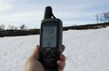
GPS @ the hashpoint
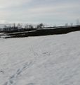
The hashpoint
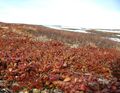
Intense colors
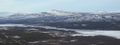
View towards Kebnekaise
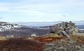
Someone had built this at the summit, I added a couple of stones as well
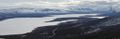
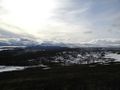
View southwest over Paittasjärvi, the 2009-04-20 67 19 hashpoint is next to that cape
Southeast
Hash Mountain


The area had many rather... bizarre trees. They looked like they had snapped at a young age, but kept growing and curled around themselves. They were just below the treeline, so I guess they are stretching the limits on where pinetrees are supposed to grow.


