Difference between revisions of "2009-05-18 52 9"
From Geohashing
imported>Chrismz (New page: {{meetup graticule | lat=52 | lon=9 | date=2009-05-18 }} == About == Today's geohash was located right at the end of the small village of Bennemühlen (330 inhabitants, one fire brigade c...) |
imported>Chrismz |
||
| Line 19: | Line 19: | ||
Image:2009-05-18_52_9_hash.jpg|the geohash | Image:2009-05-18_52_9_hash.jpg|the geohash | ||
Image:2009-05-18_52_9_field.jpg|the hashpoint was located a couple of meters into this field | Image:2009-05-18_52_9_field.jpg|the hashpoint was located a couple of meters into this field | ||
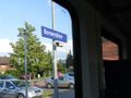
| − | Image:2009-05-18_52_9_sign.jpg|looking into the | + | Image:2009-05-18_52_9_sign.jpg|looking into the opposite direction |
Image:2009-05-18_52_9_train.jpg|getting back | Image:2009-05-18_52_9_train.jpg|getting back | ||
Image:2009-05-18_52_9_intrain.jpg|inside the train | Image:2009-05-18_52_9_intrain.jpg|inside the train | ||
Revision as of 19:22, 18 May 2009
| Mon 18 May 2009 in 52,9: 52.5811355, 9.7205812 geohashing.info google osm bing/os kml crox |
About
Today's geohash was located right at the end of the small village of Bennemühlen (330 inhabitants, one fire brigade car) north of Hannover.
Expedition by Chrismz
I took the S4 train at 5h11 pm from Hannover main station to Bennemühlen. After a 30min train ride and a short walk to cross the train track safely the hashpoint was easily reached.
Trivia
The geohash even had something a little bit special for me since I just had to get the latitude right because my "keyboard's coordinates" differed just about 2 seconds from the hash's longitude.
Gallery
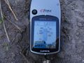
the geohash
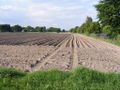
the hashpoint was located a couple of meters into this field
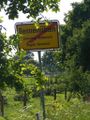
looking into the opposite direction
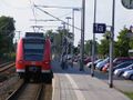
getting back
inside the train


Achievements
I'm claiming for myself:
Chrismz earned the Public transport geohash achievement
|