Difference between revisions of "2009-05-21 35 -78"
From Geohashing
imported>Ncbears m (burp II) |
imported>Jiml m (Fix sort ordeer) |
||
| Line 40: | Line 40: | ||
[[Category:Expeditions with photos]] | [[Category:Expeditions with photos]] | ||
[[Category:Coordinates reached]] | [[Category:Coordinates reached]] | ||
| − | [[Category:Geohashing_Day_achievement | + | [[Category:Geohashing_Day_achievement]] |
Revision as of 06:04, 23 May 2012
| Thu 21 May 2009 in 35,-78: 35.8587364, -78.5438145 geohashing.info google osm bing/os kml crox |
Participants
Eisen & Bear - NCBears
Geological Features
Rolling topography next to interstate highway I-540, northeast of Raleigh. In field.
Wildlife Encounters
None
Weather
Low 80°F/26°C, partly cloudy, wind 5mph/8kph
Report & Pictures
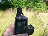
Finding the Geohash was easy. In a field alongside I-540 near an exit ramp.
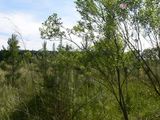
Once part of a farm that has been crowded out by development.
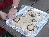
Our celebratory hash cake (actually Rice Krispies treat with chocolate chip highlights). Bear let me lick the spoon last night.
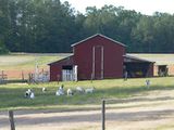
On the way home.
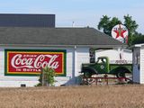
Americana at a tobacco farm.


