Difference between revisions of "2009-06-13 -37 144"
imported>MykaDragonBlue m (Bing!) |
imported>MykaDragonBlue m (→myka: photos) |
||
| Line 33: | Line 33: | ||
== Photos == | == Photos == | ||
==== myka ==== | ==== myka ==== | ||
| − | + | <gallery perrow="4"> | |
| − | + | Image:2009-06-13_-37_144 mdb 001.jpg| I thought the has was in here. | |
| − | <gallery perrow=" | + | Image:2009-06-13_-37_144_mdb_002.jpg| Actually, it was over there. |
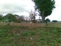
| − | Image:2009-06-13_-37_144 mdb 001.jpg| | + | Image:2009-06-13_-37_144_mdb_003.jpg| possibly Fergus Found it! |
| − | Image:2009-06-13_-37_144_mdb_002.jpg| | + | Image:2009-06-13_-37_144_mdb_004.jpg| bad shot ... very bad proof. |
| − | Image:2009-06-13_-37_144_mdb_003.jpg| | + | Image:2009-06-13_-37_144_mdb_005.jpg| trees -> piles of scrap. sad |
| − | Image:2009-06-13_-37_144_mdb_004.jpg| | ||
| − | |||
| − | |||
| − | |||
| − | |||
| − | Image:2009-06-13_- | ||
| − | |||
</gallery> | </gallery> | ||
| − | |||
Revision as of 14:14, 14 June 2009
| Sat 13 Jun 2009 in -37,144: -37.3405468, 144.5376857 geohashing.info google osm bing/os kml crox |
Contents
The location
In a small treed area in the town of Woodend, not far from the calder highway.
Who Went?
myka
I was going to Bendigo, so i decided to check the hashes for the day. Lo and Behold, there was a point just off the highway, and it appeared to be in woodend. I was slightly worried as I checked it that the point would end up in either a backyard or a paddock, both of which would be bad. Closer inspection of google mappage however, suggested that the point was in a small wooded lot on the outrskirts of town.
The lot was so small and regular in fact, that I was worried that it was just a heavily treed house and yard. But I decided to have a look anyway.
I turned off the Highway, and pulled over outside Woodend to set up my GPS. I copied the coordiantes across from the screenshot on my phone, and headed towards the hash. This would have to be a fairly quick success or lack thereof, as I was somewhat late already.
I drove down the appropriate road, looking for the first treed section to the left. Shortly I found it. So, it is indeed a property, with letterbox, gate, and a house. ahh well.
But wait... on closer inspection, the GPS doesn't just say the hash is a few hundred meters away (yes, it was a big block of land, with that sort of room)... but it says the point is a few hundred meters away in that direction... which is... reachable... ...probably.
I drove back down the road a bit, folllowing the GPS, and it appeared to be pointing to a totally clear set of empty blocks. huh? but there were trees on the sat-map.
I could drive onto the lot, so i parked, and wandered around untill I found the point. took a couple of photos and beed confuddled for a bit before figuring out what was up.
It turned out that the trees had been cleared since the satellite shots were taken. also, a number of houses had been built. I suspect the clearing is to facilitate further building. It's a pity really.
Without further ado, I drove on to Bendigo, and other places.
Photos
myka
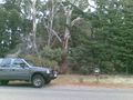
I thought the has was in here.
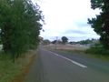
Actually, it was over there.

possibly Fergus Found it!
bad shot ... very bad proof.
trees -> piles of scrap. sad


