Difference between revisions of "2009-06-14 42 -72"
imported>Mom |
imported>Sara m (adding photos) |
||
| Line 1: | Line 1: | ||
<!-- If you did not specify these parameters in the template, please substitute appropriate things for IMAGE, LAT, LON, and DATE (YYYY-MM-DD format) --> | <!-- If you did not specify these parameters in the template, please substitute appropriate things for IMAGE, LAT, LON, and DATE (YYYY-MM-DD format) --> | ||
| − | + | [[Image:{{{image|2009_06_15_42_-72_church.jpg}}}|thumb|left]] | |
| − | [[Image:{{{image| | ||
| − | |||
{{meetup graticule | {{meetup graticule | ||
| lat=42 | | lat=42 | ||
| Line 23: | Line 21: | ||
== Expedition == | == Expedition == | ||
| − | I have been waiting for a while to find a geohash close enough to home that fit well enough with the family's schedule, and today was the day. I drove there and arrived around 8:00 pm. It was my very first hash and it turned out to be a Holy Hash! I didn't have a GPS, so I relied on Google's aerial photo. | + | I have been waiting for a while to find a geohash close enough to home that fit well enough with the family's schedule, and today was the day. I drove there and arrived around 8:00 pm. It was my very first hash and it turned out to be a Holy Hash! I didn't have a GPS, so I relied on Google's aerial photo. When I got there, it was hard to reconcile what I remembered seeing on the computer with reality - it looked as if the building might have been rebuilt since the aerial photo was taken, or anyway I wasn't sure exactly where the point was, so I walked all along that side of the church to make sure I visited the correct point. At home I looked at the satellite photo again and confirmed that the grin picture was in fact taken at the hashpoint. |
| Line 29: | Line 27: | ||
== Photos == | == Photos == | ||
| − | |||
| − | |||
<gallery perrow="3"> | <gallery perrow="3"> | ||
| − | Image: | + | Image:2009_06_15_42_-72_church.jpg | The churc, which has a coffee shop inside it. |
| − | Image: | + | Image:2009_06_15_42_-72_signs.jpg | I don't have a GPS yet, but these signs show that I was at the correct church. |
| + | Image:2009_06_15_42_-72_grin.jpg | The one good thing about this picture is: This is my first hash, and the pictures of me grinning can only get better. | ||
</gallery> | </gallery> | ||
| Line 40: | Line 37: | ||
[[Category:Expedition without GPS]] | [[Category:Expedition without GPS]] | ||
[[Category:Coordinates reached]] | [[Category:Coordinates reached]] | ||
| + | [[Category:Expeditions with photos]] | ||
Revision as of 00:50, 6 July 2009

| Sun 14 Jun 2009 in 42,-72: 42.0595272, -72.7652863 geohashing.info google osm bing/os kml crox |
About
This location was at a Lutheran church in Southwick, Massachusetts. I was surprised to find that the church had a coffee shop inside it.
Participants
Expedition
I have been waiting for a while to find a geohash close enough to home that fit well enough with the family's schedule, and today was the day. I drove there and arrived around 8:00 pm. It was my very first hash and it turned out to be a Holy Hash! I didn't have a GPS, so I relied on Google's aerial photo. When I got there, it was hard to reconcile what I remembered seeing on the computer with reality - it looked as if the building might have been rebuilt since the aerial photo was taken, or anyway I wasn't sure exactly where the point was, so I walked all along that side of the church to make sure I visited the correct point. At home I looked at the satellite photo again and confirmed that the grin picture was in fact taken at the hashpoint.
I had never before seen a church with a coffee shop inside it, although I had heard about them.
Photos
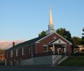
The churc, which has a coffee shop inside it.
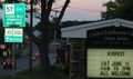
I don't have a GPS yet, but these signs show that I was at the correct church.
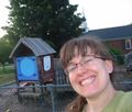
The one good thing about this picture is: This is my first hash, and the pictures of me grinning can only get better.

