Difference between revisions of "2009-06-26 48 11"
From Geohashing
imported>Tomcat (New page: == Expedition == In a forest 7 km south of Hemau. Hans and Tomcat went there by bike in the evening. == Photos == <gallery> Image:2009-06-26_48_11_on_the_bike.jpg | On the way to the ...) |
imported>Dawidi (+ meetup template) |
||
| Line 1: | Line 1: | ||
| + | {{meetup graticule | ||
| + | | map=<map lat="48" lon="11" date="2009-06-26" /> | ||
| + | | lat=48 | ||
| + | | lon=11 | ||
| + | | date=2009-06-26 | ||
| + | | graticule_name=München, Germany | ||
| + | | graticule_link=München, Germany}} | ||
== Expedition == | == Expedition == | ||
In a forest 7 km south of Hemau. Hans and Tomcat went there by bike in the evening. | In a forest 7 km south of Hemau. Hans and Tomcat went there by bike in the evening. | ||
| Line 13: | Line 20: | ||
</gallery> | </gallery> | ||
| − | |||
[[Category:Expeditions with photos]] | [[Category:Expeditions with photos]] | ||
[[Category:Coordinates reached]] | [[Category:Coordinates reached]] | ||
Revision as of 10:38, 1 July 2009
| Fri 26 Jun 2009 in München, Germany: 48.9886395, 11.7552430 geohashing.info google osm bing/os kml crox |
Expedition
In a forest 7 km south of Hemau. Hans and Tomcat went there by bike in the evening.
Photos
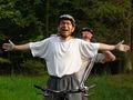
On the way to the hash.
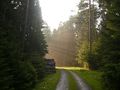
Forest near the hashpoint.
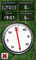
Hit the point.
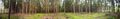
360° panoramic view at the hash.
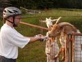
Making new friends is easy if you have candy with you.


