Difference between revisions of "2009-07-05 45 -123"
imported>Jiml m (cleanup) |
imported>Jiml (Complete report) |
||
| Line 10: | Line 10: | ||
The hashpoint is about 300 feet from the Pumpkin Ridge Road. It was not in the | The hashpoint is about 300 feet from the Pumpkin Ridge Road. It was not in the | ||
| − | nearby pond as | + | nearby pond as one neighbor speculated. |
== Participants == | == Participants == | ||
| Line 28: | Line 28: | ||
=== Jim === | === Jim === | ||
| − | + | It was another pretty Oregon day. It wasn't as hot as yesterday, which was nice. | |
| − | |||
| − | When I got closer, it was | + | I finally found the road into this section of North Plains. I hadn't printed details on the Google map page, and I |
| + | was being too male to pull out the Thomas Guide and look at it. | ||
| + | |||
| + | When I got closer, it was a bit past 4PM, but there was no sign of anyone else. I parked on a side road | ||
and walked back, finding a point on the road that was 300 feet away. It seemed like too far to venture without | and walked back, finding a point on the road that was 300 feet away. It seemed like too far to venture without | ||
permission, so I started to ask neighbors who owned the land. | permission, so I started to ask neighbors who owned the land. | ||
| − | + | The first neighbor reported that the land right next to the road belonged to someone who lived | |
| − | + | up the road. However, since I had to go in 300 feet, he thought I might end up in a pond back there | |
| − | + | that belonged to someone else. He directed me to a nearby road, which happened to be where I had parked my car. | |
| + | |||
| + | I found what I thought was the correct owner, which was a riding stable. However, the owner wasn't around. But | ||
| + | the people there didn't think there was a pond. (It wasn't on the map up on the wall.) But they suggested | ||
| + | asking another neighbor. I went over there, and it turned out the pond did belong to him. Apparently, | ||
| + | the road used to run right next to the pond, when the local Pony Express horses were stabled in this | ||
| + | area. The county apparently decided to move the road without quite doing things right, which sometimes happens | ||
| + | around here. | ||
| + | |||
| + | He was concerned that someone had placed a geocache on his property with out his permission, but I explained that | ||
| + | it was just the coordinates that were randomly chosen that we were interested in. | ||
| + | We talked for a while about local history and the artesian springs that feed his pond and the beavers that | ||
| + | live there. Then he pointed me towards the pond and I changed to boots and headed off. It was open | ||
| + | field at the start, but soon I encountered a wall of brambles, with raptors hiding amid the leaves. | ||
| + | I plunged in, but found the going got rougher, so I backed up to see if I could get around them. | ||
| + | |||
| + | An end-run around the brambles was more successful, and I found myself in a open section of field, with the | ||
| + | feet-to-hashpoint dropping to 200ft, then 100ft. Then I ran out of field. The forest looked imposing, | ||
| + | but I found a way in. I soon discovered that the GPS unit wasn't happy with the amount | ||
| + | of signal it was getting. It kept pointing 50ft one way, then 50ft in another. I slowed down and | ||
| + | it became somewhat more stable, but with the leafy cover, it wasn't going to be quite as accurate. | ||
| + | |||
| + | I finally found a spot that the GPS said was 4ft away, and I decided to call it good, since every | ||
| + | other nearby point that was "20 feet". Also, the local defensive raptor squad had been | ||
| + | activated, and they were attacking me. Apparently, they were vampire raptors, because they seemed to | ||
| + | be interested in my blood, and not for the same reasons the local Red Cross likes it. However, | ||
| + | the attacks kept my picture taking to a minimum, and a fuzzy one at that. I was also wary of | ||
| + | yellow jacket raptors, who will eat what the vampire raptors leave behind. | ||
| + | |||
| + | I escaped out of the woods, unharmed as far as I can tell, and headed for home. | ||
| + | |||
| + | ==Achievements== | ||
| + | {{land geohash | latitude = 45 | longitude = -123 | date = 2009-07-05 | name = [[User:Jiml|Jim]] }} | ||
| + | {{Ambassador geohash | ||
| + | | latitude = 45 | ||
| + | | longitude = -123 | ||
| + | | date = 2009-07-05 | ||
| + | | name = [[User:Jiml|Jim]] | ||
| + | }} | ||
== Tracklog == | == Tracklog == | ||
| Line 46: | Line 86: | ||
== Photos == | == Photos == | ||
| − | |||
| − | + | <gallery perrow="4"> | |
| − | <gallery perrow=" | + | Image:2009-07-05 45 123-Permission-Needed.png | Yes, we need to ask |
| − | Image:2009- | + | Image:2009-07-05 45 123-RouteIn.png | Route to midpoint from road |
| − | Image:2009- | + | Image:2009-07-05 45 123-Route-Out.png | Route to hashpoint |
| + | Image:2009-07-05 45 123-Brambles.png | Raptors with roots | ||
| + | Image:2009-07-05 45 123-GPS.png | GPS at hashpoint | ||
</gallery> | </gallery> | ||
| − | + | ||
[[Category:Expeditions]] | [[Category:Expeditions]] | ||
[[Category:Expeditions with photos]] | [[Category:Expeditions with photos]] | ||
[[Category:Coordinates reached]] | [[Category:Coordinates reached]] | ||
Revision as of 05:00, 6 July 2009
| Sun 5 Jul 2009 in 45,-123: 45.3518423, -123.1062209 geohashing.info google osm bing/os kml crox |
Location
A patch of woods close to Pumpkin Ridge Golf Course, in North Plains, Oregon. (Yes, golf fans, that Pumpkin Ridge.)
The hashpoint is about 300 feet from the Pumpkin Ridge Road. It was not in the nearby pond as one neighbor speculated.
Participants
Plans
Jim and 3riador didn't manage to meet up.
Expedition
Jim
It was another pretty Oregon day. It wasn't as hot as yesterday, which was nice.
I finally found the road into this section of North Plains. I hadn't printed details on the Google map page, and I was being too male to pull out the Thomas Guide and look at it.
When I got closer, it was a bit past 4PM, but there was no sign of anyone else. I parked on a side road and walked back, finding a point on the road that was 300 feet away. It seemed like too far to venture without permission, so I started to ask neighbors who owned the land.
The first neighbor reported that the land right next to the road belonged to someone who lived up the road. However, since I had to go in 300 feet, he thought I might end up in a pond back there that belonged to someone else. He directed me to a nearby road, which happened to be where I had parked my car.
I found what I thought was the correct owner, which was a riding stable. However, the owner wasn't around. But the people there didn't think there was a pond. (It wasn't on the map up on the wall.) But they suggested asking another neighbor. I went over there, and it turned out the pond did belong to him. Apparently, the road used to run right next to the pond, when the local Pony Express horses were stabled in this area. The county apparently decided to move the road without quite doing things right, which sometimes happens around here.
He was concerned that someone had placed a geocache on his property with out his permission, but I explained that it was just the coordinates that were randomly chosen that we were interested in. We talked for a while about local history and the artesian springs that feed his pond and the beavers that live there. Then he pointed me towards the pond and I changed to boots and headed off. It was open field at the start, but soon I encountered a wall of brambles, with raptors hiding amid the leaves. I plunged in, but found the going got rougher, so I backed up to see if I could get around them.
An end-run around the brambles was more successful, and I found myself in a open section of field, with the feet-to-hashpoint dropping to 200ft, then 100ft. Then I ran out of field. The forest looked imposing, but I found a way in. I soon discovered that the GPS unit wasn't happy with the amount of signal it was getting. It kept pointing 50ft one way, then 50ft in another. I slowed down and it became somewhat more stable, but with the leafy cover, it wasn't going to be quite as accurate.
I finally found a spot that the GPS said was 4ft away, and I decided to call it good, since every other nearby point that was "20 feet". Also, the local defensive raptor squad had been activated, and they were attacking me. Apparently, they were vampire raptors, because they seemed to be interested in my blood, and not for the same reasons the local Red Cross likes it. However, the attacks kept my picture taking to a minimum, and a fuzzy one at that. I was also wary of yellow jacket raptors, who will eat what the vampire raptors leave behind.
I escaped out of the woods, unharmed as far as I can tell, and headed for home.
Achievements
Jim earned the Land geohash achievement
|
Jim earned the Ambassador achievement
|
Tracklog
I think I got it to upload!
Photos
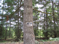
Yes, we need to ask
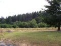
Route to midpoint from road
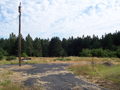
Route to hashpoint
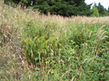
Raptors with roots
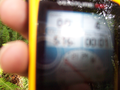
GPS at hashpoint


