Difference between revisions of "2009-05-16 40 -74"
From Geohashing
imported>Zubenelgenubi |
imported>Danatar m |
||
| Line 24: | Line 24: | ||
Image:20090516_bas_2.JPG| | Image:20090516_bas_2.JPG| | ||
Image:20090516_bas_3.JPG| The vista of Alexauken Valley, about 5 miles beyond the hashpoint | Image:20090516_bas_3.JPG| The vista of Alexauken Valley, about 5 miles beyond the hashpoint | ||
| − | </gallery | + | </gallery> |
| + | [[Category:Expeditions]] | ||
[[Category:Expeditions with photos]] | [[Category:Expeditions with photos]] | ||
[[Category:Coordinates not reached]] | [[Category:Coordinates not reached]] | ||
| − | [[Category:Not reached - | + | [[Category:Not reached - Mother Nature]] |
Revision as of 12:42, 7 July 2009
| Sat 16 May 2009 in 40,-74: 40.3770048, -74.7785416 geohashing.info google osm bing/os kml crox |
Participants
Plans
The point was in the forest several hundred feet from Pennington Hopewell Road and perhaps two hundred feet from an East Drive. Reaching the exact coordinates or finding anyone else there both seemed unlikely, but it was a picturesque area for a bike ride.
Expedition
"East Drive" does not, in fact, exist, and while the roadside was not covered with "No Trespassing" signs, I did not go wandering into the woods to find a set of coordinates that I had neglected to even write down. Altogether, the expedition was uneventful. The nearest velociraptor population is (I have heard) a few valleys to the northwest.
Photos
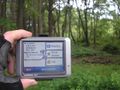
As close as I could remember the coordinates

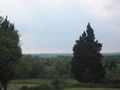
The vista of Alexauken Valley, about 5 miles beyond the hashpoint


