Difference between revisions of "2009-07-08 -38 145"
From Geohashing
imported>Felix Dance (New page: {{meetup graticule | map=<map lat="-38" lon="145" date="2009-07-08" /> | lat=-37 | lon=145 | date=2009-07-08 }} == The Place == -38.126703°, 145.363957°. To the south east of Cranbour...) |
imported>Felix Dance |
||
| Line 15: | Line 15: | ||
I'd just bought a new pair of cycling shoes when I discovered the location for this hash point... | I'd just bought a new pair of cycling shoes when I discovered the location for this hash point... | ||
| + | |||
| + | Go here [http://maps.google.com/maps?f=d&source=s_d&saddr=395+Bay+St,+Port+Melbourne+VIC+3207,+Australia+(Home,+Paint+and+Wallpaper)&daddr=-37.842665,144.938593+to:Beach+Rd+to:Austin+Rd+to:Seaford+Rd+to:Frankston+Dandenong+Rd+to:Cranbourne+Frankston+Rd+to:Pattersons+Rd+to:-38.126703%C2%B0,+145.363957%C2%B0+to:Pattersons+Rd+to:Cameron+St+to:cranbourne+railway+station&hl=en&geocode=%3B%3BFUplvP0d6uWkCA%3BFVaPuv0djIymCA%3BFdN-uv0dtpamCA%3BFV6Zuv0dnB2nCA%3BFfp1uv0dLq2oCA%3BFVlQuv0dGdupCA%3BFZE7uv0d9ROqCA%3BFftTuv0djLypCA%3BFSKKuv0dmPeoCA%3BFeOjuv0dls6oCCFNkJjjoRDwHg&mra=dpe&mrcr=0&mrsp=1&sz=15&via=1,2,3,4,5,6,7,9,10&sll=-37.846189,144.94709&sspn=0.027077,0.038581&safe=on&ie=UTF8&ll=-38.100336,145.280319&spn=0.017764,0.045834&z=14] for the Google Maps route I took | ||
== Photos == | == Photos == | ||
<gallery perrow="3"> | <gallery perrow="3"> | ||
| − | Image:Bikeatgeohash090708. | + | Image:Bikeatgeohash090708.JPG|My bike near the geohash location. |
| − | Image:GPS090708. | + | Image:GPS090708.JPG|80m from geohash - I did get there by couldn't take a photo. |
| − | Image:LamingRacingSign090708. | + | Image:LamingRacingSign090708.JPG|The sign for the race track. |
| − | Image:TowardsHashPoint090708. | + | Image:TowardsHashPoint090708.JPG|The hash point is just beyond the limit of the flash. |
</gallery> | </gallery> | ||
Revision as of 00:36, 9 July 2009
| Wed 8 Jul 2009 in -37,145: -37.1267020, 145.3639574 geohashing.info google osm bing/os kml crox |
Contents
The Place
-38.126703°, 145.363957°. To the south east of Cranbourne in Melbourne's south east.
Who is going
Felix Dance
I'd just bought a new pair of cycling shoes when I discovered the location for this hash point...
Go here [1] for the Google Maps route I took
Photos

My bike near the geohash location.
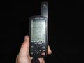
80m from geohash - I did get there by couldn't take a photo.

The sign for the race track.
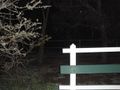
The hash point is just beyond the limit of the flash.


