Difference between revisions of "2009-07-20 59 18"
imported>LoneTech m (let's see if this gets the template right...) |
imported>LoneTech (filled in a report) |
||
| Line 1: | Line 1: | ||
| − | |||
<!-- If you did not specify these parameters in the template, please substitute appropriate things for IMAGE, LAT, LON, and DATE (YYYY-MM-DD format) --> | <!-- If you did not specify these parameters in the template, please substitute appropriate things for IMAGE, LAT, LON, and DATE (YYYY-MM-DD format) --> | ||
<!-- | <!-- | ||
| Line 13: | Line 12: | ||
__NOTOC__ | __NOTOC__ | ||
== Location == | == Location == | ||
| − | + | In the water between Vindö and Gällnö. | |
== Participants == | == Participants == | ||
| − | + | [[User:LoneTech|Yann Vernier]], [[User:Gnitset|Klas Meder Boqvist]] | |
== Plans == | == Plans == | ||
| − | + | Not much to speak of; just visit there by boat (same one we used to reach the island house in the first place). We thought the proximity of the geohash was simply too lucky to not go. | |
== Expedition == | == Expedition == | ||
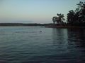
| − | + | We were delayed due to a lack of boat, as Gnitset's parents had gone to shop. They returned only minutes before sundown, so we had some pretty nice skies to watch during our trip. Still, it was short and largely uneventful, except for a lucky encounter with a small roe deer who was swimming across between islands. On our way back we stopped by Svartsö looking for the results from a running race there (Svartsöruset), but didn't find anything. | |
== Tracklog == | == Tracklog == | ||
| − | + | [http://donkey.vernier.se/~yann/geohash/wami-20090720.gpx GPX file] | |
== Photos == | == Photos == | ||
| − | <gallery perrow=" | + | <gallery perrow="4"> |
| − | Image:2009- | + | Image:2009-07-20 59 18 map.jpg | Simply too close not to go. |
| − | Image:2009- | + | Image:2009-07-20 59 18 sunset.jpg | We didn't have much daylight left. |
| + | Image:2009-07-20 59 18 gnitset.jpg | Silly grin at the geohash. | ||
| + | Image:2009-07-20 59 18 roe deer.jpg | A deer out for a swim. | ||
</gallery> | </gallery> | ||
| − | |||
| − | |||
| − | |||
| − | |||
| − | |||
| − | |||
| − | |||
| − | |||
[[Category:Expeditions]] | [[Category:Expeditions]] | ||
[[Category:Expeditions with photos]] | [[Category:Expeditions with photos]] | ||
| − | |||
| − | |||
| − | |||
| − | |||
| − | |||
[[Category:Coordinates reached]] | [[Category:Coordinates reached]] | ||
| − | |||
| − | |||
| − | |||
| − | |||
| − | |||
| − | |||
| − | |||
| − | |||
| − | |||
| − | |||
Revision as of 15:25, 31 July 2009
| Mon 20 Jul 2009 in 59,18: 59.3827741, 18.6606590 geohashing.info google osm bing/os kml crox |
Location
In the water between Vindö and Gällnö.
Participants
Yann Vernier, Klas Meder Boqvist
Plans
Not much to speak of; just visit there by boat (same one we used to reach the island house in the first place). We thought the proximity of the geohash was simply too lucky to not go.
Expedition
We were delayed due to a lack of boat, as Gnitset's parents had gone to shop. They returned only minutes before sundown, so we had some pretty nice skies to watch during our trip. Still, it was short and largely uneventful, except for a lucky encounter with a small roe deer who was swimming across between islands. On our way back we stopped by Svartsö looking for the results from a running race there (Svartsöruset), but didn't find anything.
Tracklog
Photos
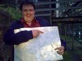
Simply too close not to go.
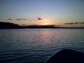
We didn't have much daylight left.
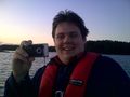
Silly grin at the geohash.
A deer out for a swim.


