Difference between revisions of "2009-08-28 61 23"
imported>Jil |
imported>Jil |
||
| Line 7: | Line 7: | ||
| lon=23 | | lon=23 | ||
| date=2009-08-28 | | date=2009-08-28 | ||
| + | | graticule_name=Tampere | ||
| + | | graticule_link=Tampere, Finland | ||
}} | }} | ||
| Line 39: | Line 41: | ||
== Tracklog == | == Tracklog == | ||
I used [http://sportstracker.nokia.com Nokia Sports Tracker] software on one of the phones to track the route from the nearest forest road. There seems to be a small offset, though: starting and ending points should be on the road. | I used [http://sportstracker.nokia.com Nokia Sports Tracker] software on one of the phones to track the route from the nearest forest road. There seems to be a small offset, though: starting and ending points should be on the road. | ||
| − | [http://sportstracker.nokia.com/nts/workoutdetail/index.do?id=1494963 Link to route in Nokia Sports Tracker | + | [http://sportstracker.nokia.com/nts/workoutdetail/index.do?id=1494963 Link to route] in Nokia Sports Tracker web site. |
== Photos == | == Photos == | ||
| Line 48: | Line 50: | ||
--> | --> | ||
<gallery perrow="3"> | <gallery perrow="3"> | ||
| − | Image:090828-dangerous-road.jpg|Forest road has a promising start. Caution: Dangerous road | + | Image:090828-dangerous-road.jpg|Forest road has a promising start. 'Caution: Dangerous road.' |
| − | Image:090828-stalking-tower2.jpg|There are stalking towers for moose hunt along the road every ~200 metres | + | Image:090828-stalking-tower2.jpg|There are stalking towers for moose hunt along the road every ~200 metres. |
Image:090828-gps-proof.jpg|Weak try for a proof... | Image:090828-gps-proof.jpg|Weak try for a proof... | ||
| − | Image:090828-gps-location.jpg|Close-up | + | Image:090828-gps-location.jpg|Close-up. |
| − | Image:090828-globe-pose.jpg|Nice start for geohashing: happened to have a globe in the trunk today | + | Image:090828-globe-pose.jpg|Nice start for geohashing: I happened to have a globe in the trunk today. |
| − | Image:090828-wet-shoes.jpg|The result after | + | Image:090828-wet-shoes.jpg|The result after dashing to the forest without any preparation. Could have been worse. |
</gallery> | </gallery> | ||
Revision as of 12:13, 29 August 2009
| Fri 28 Aug 2009 in Tampere: 61.5643503, 23.9348701 geohashing.info google osm bing/os kml crox |
Location
Today's geohash for Tampere graticule. Located in Sorila, Tampere.
Meetup location:
- 61.56435°, 23.93487° or
- N61°33.861', E23°56.0922' or
- N61°33'51.66", E23°56'5.53"
Participants
jil - ETA 16:30
Plans
This is my first geohash - I heard about geohashing just today. In the spirit I'm going to grab a couple of cellphones with integrated camera and GPS and head to the forest straight from work with no particular plan - wearing small leather shoes and hoping it's not too wet out there.
Expedition
I chose to check this thing out because I had some free time after work and the hash location was in an area I knew somehow, although I had never been there in the forest on foot. Getting there was easy - using a small unpaved country road I could drive quite close to the location without resorting to a map or GPS. The location was only ~150 metres away from the country road.
I parked the car beside a stalking tower they use to hunt for moose. Just seconds after stepping off the road I remembered why I hate trekking in Finland late summer or early autumn. The forest was full of nasty little creatures, deer flies, and they chose me instead of moose they're supposed to harass. The hash point was located in an old clear cut forest area. The cutting took place ~6 years ago, and now the terrain is covered with some new growth.
While driving towards the geohash site I remembered I had a globe map in the trunk of the car. I was going to see my god son later in the evening and give the globe to him. But now in the forest road I took the globe with me and started the short walk to the hash spot. The approximate position was easily found, but I noticed that standard S60 software doesn't give you exact location data: couple of decimals are missing, and you can't get date/time on screen at the same time with coordinates. The tracklog may help a bit in verifying the results anyway. I arrived to geohash location at 16:20.
Citizen's MapSite shows detailed view to geohash location:
Tracklog
I used Nokia Sports Tracker software on one of the phones to track the route from the nearest forest road. There seems to be a small offset, though: starting and ending points should be on the road. Link to route in Nokia Sports Tracker web site.
Photos
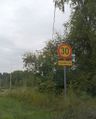
Forest road has a promising start. 'Caution: Dangerous road.'
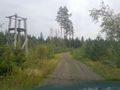
There are stalking towers for moose hunt along the road every ~200 metres.
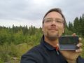
Weak try for a proof...

Close-up.

Nice start for geohashing: I happened to have a globe in the trunk today.
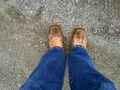
The result after dashing to the forest without any preparation. Could have been worse.


Ribbons Earned
jil earned the Land geohash achievement
|